|
UNIVERSITÁ DEGLI STUDI DI MILANO-BICOCCA |
|
|
|
Dipartimento di Scienze Geologiche e Geotecnologie |
Papers presented
to
the 1999 Workshop Meeting of
TE.CO.S.
"Relationships Between Impacts and
Geological Boundaries"
September, 6 - 10
1999
Castelnovo ne’Monti (RE)
Italy
(with Field Trips Guide)
Edited by:
Alessandro Colombetti
Technical Editor: Francesco Nicolodi
Introduction
After the Budapest meeting, during which there was a confrontation between outstanding researchers of this new science, that has demonstrated having new possibilities of giving a new interpretation key for clarifying some of the most important problems of the life evolution on our planet, now we meet all together in Italy, at Castelnovo ne’Monti.
In these months we lived a period of difficulties whether for international facts or for the problems of the IGCP384.
In this meeting there is the presentation of a new group – TE. CO. S. (Terrestrial and Cosmic Spheres), born to the probing and the developing of the spherule studies.
It’s in the logic of the events that, when there are new research fields, there are also the critics, the dissentings or people that desire to be research co-ordinators only for the prestige.
We leave in the margin these facts, more important for someone, but we want to know more new data and to ascertain with a very deep research about the microspherules their real diffusion during the geological boundaries and the most important events of the Earth.
Some researchers have proposed to insert a new section about recent microspherules or special macrospheres sampled in different sediments.
During this meeting we can discuss also this argument.
To all the participants and to the people who have contributed to the organisation of this meeting I give my greetings and wishes of good work!
Prof. Alessandro Colombetti
Organising Committee of the
Castelnovo Workshop
This meeting is made under the authority of:
The K/T Boundary in Brazilian Marginal Sedimentary Basins and Related Spherules
G. A. ALBERTÃO (PETROBRAS) and A. A. GRASSI (PETROBRAS)
Despite the non-existence of studies on details for an identification of a complete section with a K-T transition in the Brazilian sedimentary basins, some areas (outcrop data) and drilling wells (subsurface data) have been selected on a PETROBRÁS data basis and studied since 1990. Drilling wells from Campos, Espírito Santo and Sergipe/Alagoas Basins and some outcrops from the Pernambuco/Paraíba Basin (PE/PB Basin) were more extensively studied.
Geochemical analyses performed on ditch samples (from subsurface data) were submitted to statistical tests such as factor and discriminant analyses. The result of the factor analysis led to the definition of groups of chemical elements representative of various profiles; it also attested conspicuous ciclicities of inter-regional character; the discriminant analysis showed not only a very clear discontinuity of the chemical data but also of the mineralogy data between the Cretaceous and Tertiary periods.
A most detailed characterisation of some spherules from the K-T boundary in PE/PB Basin is now under development in the scope of the IGCP 384 Project. The PE/PB Basin occurs in a narrow on-shore area of NE Brazil and up to now its Poty quarry is the unique known sedimentary section in this country with outcrops spanning the K-T boundary. At the present moment, just three samples (beds, in fact) were selected for the analyses. These samples were chosen due to their proximity to the K-T boundary and one of them presents the iridium anomaly. Most of these spherules occur with spherical to semi-spherical and sometimes oval or triangular shape, the colours vary from dark-brown to opalescent-white and the size is particularly small (80-200 micrometers). From preliminary observations, it appears that the majority of the sampled spherules show no obvious connection with tektites.
Recent studies indicate that a core from an oil well drilled in the 70’s in the Campos Basin recovered a succession apparently continuous spanning the Cretaceous-Tertiary boundary (KTB), as shown by calcareous nannofossil analyses. It includes a 2.5-cm thick layer of spherules interpreted as tektites directly ascribed to KTB event itself. The tektites are dark-grey to black, subspherical, with 0.3 to 1.4 mm of diameter. They were also extensively replaced by calcite and pyrite, but several of them display internal features suggesting flow and devitrification textures of the original glass, which is preserved as minor inclusions in only a few tektites. Glass chemical composition is very similar to the tektites from Haiti as shown by microprobe analyses; this is an indication that such tektites are the most distant known record of glass and of the low angle ejecta from the Chicxulub impact structure (~7.800 km).
___________________________________________________________________________
Olivine spherules and droplets from the pannonian basalt of Szentbékkálla
Sz. Bérczi1, Cs. H. Detre2, Gy. Don2, P. Solt2, I. Uzonyi3
1
Dept. of Petrology and Geochemistry, Eötvös Loránd University, H-108 Budapest,Múzeum krt. 4a, Hungary
2
Geological Institute of Hungary, H-1143 Budapest, Stefánia út 14, Hungary3
Institute of Nuclear Research of the Hungarian Academy of Sciences (ATOMKI)H-4001 P.O.B. 51, Debrecen, Bem tér 18/c, Hungary
In the Transdanubian region of Hungary, NW from the Balaton Lake, about 2500 km2 is covered by Pannonian (Late Miocene-Late Pliocene) volcanic rocks. The alkali basalt activity started 7.9 my ago and ended 2.9 my ago. The Balaton Highland National Park is famous for its well-preserved volcanic forms, like mesas, craters, lava-flows, dykes, alginit-lakes, geyser-fields, etc. As Beaudant appreciated the beauty of the neighbouring area: „The prettiest area I have ever seen in my life!"
One brilliant pearl of this land, the Káli-Basin lies north from the vine-famous Badacsony hill (Csillag, G. 1996). Szentbékkálla is a little village at the foot of the northern rim of the basin. North from the village some outcrops and an old rock-quarry is well-studied for the famous mantle inclusions. The olivine dominated inclusions of Hungarian alkali basalts were investigated comprehensively for the first time by Embey-Isztin, A. (1976), who identified their xenolithic nature, showed their mineral composition to have been a four phase spinel-lherzolitic one and proved their upper mantle origin. The rare earth element content of the peridotite inclusions were studied by Bérczi, J. and Bérczi, Sz. (1986) and a liesegang layered clinopyroxene megacryst inclusion analysed by Bérczi, Sz. and Szabó, Cs. (1989).
Looking for different kind of different originated spherules to have a complex comparative material to distinguish the extraterrestrial ones from terrestrials and artificial (man-made, industrial produced) we decided to make a field work in this pannonian alkali basaltic area. Lava droplets are well-known from recent basalt volcanoes, where are lava-fountains. North from the rock-quarry in the Fekete-hegy great lava-flows were observed and the Kopács-hegy is a well-preserved crater and famous for its lava-bombs (Németh, K. 1996).
We have collected 6 different samples in a section of the quarry and after the laboratory work some olive-green rounded droplets, spherules, teardrops or pear-forms were found, their size 200-800 micron. Uzonyi, I. (1998) of four different samples, made the PIXE analyses. All of them have characteristic high Si-Al-Ca-Fe content and one of them has higher Cr concentration.
References
Bérczi, J., Bérczi, Sz. (1986) : Rare Earth Element content in the Szentbékkálla series of peridotite inclusions –– Act. Min.-Petr. Szeged, XVIII., pp.61-74.
Bérczi, Sz., Bérczi, Cs. (1989) : Liesegang layered clinopyroxene megacryst inclusion from Szentbékkálla, Hungary –– –– Act. Min.-Petr. Szeged, XXX., pp.5-17.
Csillag, G. (1996) : A Káli-medence földtani természetvédelmi térképsorozata –– MÁFI pp.1-20.
Embey-Isztin, A. (1976) : Felsoköpeny eredety lherzolitzárványok a magyarországi alkáli olivinbazaltos bazanitos vulkanizmus körzeteiben –– Földtani Közlöny (Bull. Hung. Geol. Soc.) 106., pp.42-51.
Németh, K. (1996) : Terepi vulkanologiai megfigyelések a Balaton-felvidéken – MÁFI kézirat, pp.1-25.
Uzonyi, I. (1998) : Részjelentés: a szferulák eredetének komplex vizsgálata – kézirat pp.1-12.
__________________________________________________________________________
Age determination of Romanoro Flysch
A. Colombetti1, G. Ferrari2 and F. Nicolodi2
1
University of Milano – Bicocca, Department of Geological Sciences and GeotechnologiesVia Mangiagalli, 34 – 20133 Milano ITALY
2
University of Milano, Department of Earth SciencesVia Mangiagalli, 34 – 20133 Milano ITALY
Metallic microspherules was found in the 2 levels of an outcrop of the Romanoro Flysch. The SEM, mineralogical and metallographical analyses have confirmed that these spherules derived from an iron meteorite.
This outcrop is located in the high Modena Apennines, near the town of Romanoro, along the Dolo Stream Valley.
The datation of the sediments and, consequently, of the meteoritic event has been very hard, due to the uncertain paleogeographic attribution of the sediments of older studies.
New data have partially clarified the age origin of the Romanoro Flysch.
Surely, by the presence of a large amount of Tertiary foraminifera (mainly we can observe an Eocene – Oligocene fauna) in the level FR2, the age of the sediments is later than the K/T event. But the presence of Miocenic planctonic foraminifera, in bad conservation, and the results of the 86Sr/87Sr datation show a different age: Lower Miocene.
Moreover the presence of a nannoplancton fauna of Cretaceous age have complicated the situation.
During new sampling, were found glassy microspherules (microtecktites), now under analyses; in consequence of this presence we can assert an impact.
For the future the exact age and paleogeographical determinations will be important for this location.
Terrestrial spheres in northern Apennines sediments
A. Colombetti1 and F. Nicolodi2
1
University of Milano – Bicocca, Department of Geological Sciences and GeotechnologiesVia Mangiagalli, 34 – 20133 Milano ITALY
2
University of Milano, Department of Earth SciencesVia Mangiagalli, 34 – 20133 Milano ITALY
Spherules of different origin were sampled in the northern Apennines sediments.
In the "La Lezza Nuova" landslide were sampled spheres of calcite, native copper and pyrite:
___________________________________________________________________________
The Permian -Triassic supernova impact
Cs. H. Detre1, I. Tóth2, Gy. Don1, A.Z. Kiss3, I. Uzonyi3, P. Bodó4, Zs. Schléder4
1 Geological Institute of Hungary, Stefánia út 14., H-1143 Budapest, Hungary
2
Konkoly Observatory, P.O.Box 67, H-1525 Budapest, Hungary3
Institute for Nuclear Research, ATOMKI, P.O.Box 51, H-4001 Debrecen, Hungary4
Eötvös L. University, Dept of Petrology and Geochemistry, Múzeum krt 4/a, H-1088 Budapest, HungaryThe end of the Permian has been one of the most tranquil epochs of the Earth’s history; from that time no powerful orogenic movements, no volcanism of considerable importance - save the effusion of the Siberian plateau-basalts - are known and also there are no traces of the impact of some bigger celestial body like a great meteorite, a core of a comet or some micro-planet. The Permian-Triassic boundary as it is understood in traditional sense was the time of the renaissance of organic life. The crisis lasted approximately 20 million years during the Late Permian. The lasting „quiet and sneaking" character of the destructive process suggest the thought that the terrestrial and planctonic organisms may have been entirely defenceless against the increased level of the high-frequency electromagnetic and corpuscular radiations.
The characteristic phenomena of the Upper Permian are the enrichment of the 13C isotope in a measure unprecedented in the Earth’s entire history together with the fall of the amount of the oxygen in the atmosphere from 35% to 10-12% causing in this manner the „superanoxy at the end of the Permian" (see Detre,Cs.H. et al. 1998). Both phenomena are known since some 20 years, and according to several opinions just these ones could have been the causes of extinction. If we change however the facts occupying in this connection the positions of the cause and effect: that is to say by interpreting the superanoxia as an effect of the decaying biomass, then more than sufficient explanation can be found for the observed reality. In brief: the rotting biomass extracts tremendous amounts of oxygen from the atmosphere and from the seas. The extinction of more than 90% of the species resulted inevitably in the accumulation of enormous amounts of dead biomass. The characteristic lithologies of the Upper Permian are worldwide sedimentary rocks having very high organic matter content: their organic components originate from the decaying biosphere. At the beginning of the Upper Permian the biosphere had suffered a kind of tremendous blow from the effects of which it could not recover even up to now: the available estimations - although their figures are broadly scattered - all conclude in pointing out that the amount of the recent biomass should be only a fraction of that existing 250 million years ago. The oxygen content of the recent atmosphere amounts to 21%; thus being far from that 35% which characterised it 250 million years ago. The bulk of coal measures sedimented during the Upper Carboniferous - Lower Permian is many times as voluminous as the productive biomass of the recent time. From the outset of the Triassic the formation of carbonate rocks is on a leap-like increase: the rate of their Post-Triassic accumulation is approximately by an order of magnitude higher as it has been before. It seems to be a satisfactory explanation for this development that the amount of C consumed earlier by living organisms accumulated henceforth in the lithosphere.
The spherules of interstellar origin, which can be found in the Late Permian deposits provide a rather solid argument for seeing in them the interstellar dust swept together by the shock wave front of a supernova explosion. Having diameters between 3-20 µ m, they are composed preponderantly of iron (in excess of 90%) containing also some percents of Ni, Ti and Si (see Miono,S. et al. 1998). Their dimensions and elementary composition are remarkably similar in all occurrences. They were found in Hungary (in the Bükk Mountains), in Japan and South China, several occurrences of them are known in Central Asia, moreover in South Africa, Canada and the Antarctica too. These micron-sized particles which could have survived the penetration into the Earth’s atmosphere became sedimented in the Upper Permian soil or on the sea floor of that time. We have to mention here also the theory put forward by Ruderman and Truran some time ago (see Ruderman,M. -Truran,J.W. 1980). According to them it should have been possible as well that the shock wave front of a nearby supernova explosion blew off a certain amount of dust from the Moon’s surface: later these particles took part in the accumulation of geological deposits. In our case however we have to deal with spherules of interstellar origin. Based on the facts got known in this way and as an obvious explanation for their occurrence a nearby supernova explosion can be reconstructed. The spherules derived from the interstellar dust are additional evidences.
The event of the Upper Permian which during its course has dealt repeated but slow blows to the biosphere decimating but not exterminating it, moreover led to the sedimentation of the spherules may have been the result of the explosion of a supernova being then within 10 parsecs approximately from the Sun. The geological, paleontological and biostratigraphical evidences are all indicating that this explosion may have preceded the classical boundary between the Permian and the Triassic by some 20 million years.
References
Detre, Cs.H., Tóth, I., Gucsik, A., Kiss, Á., Uzonyi, I., and Bérczi, Sz., 1998. 29th LPSC Conference, p. 1030 (Houston, TX).
Miono, Sh., Detre, Cs.H., Bérczi, Sz., Don, Gy., Dosztály, L., Solt, P., Tóth, I., Uzonyi, I., and Lukács, B., 1998. 29th LPSC Conference, p. 1029 (Houston, TX).
Ruderman,M.A., Truran,J.W., 1980. Possible transfer of lunar material to Earth from a nearby supernovae Nature 284, pp.328-329.
__________________________________________________________________________
Black, magnetic spherules from the Devonian-carboniferous boundary (Montagne Noire, France) –– A preliminary report
Gy. Don1 , Cs. H. Detre1 , P. Solt1
1
Geological Institute of Hungary, H-1143 Budapest, Stefánia u. 14.
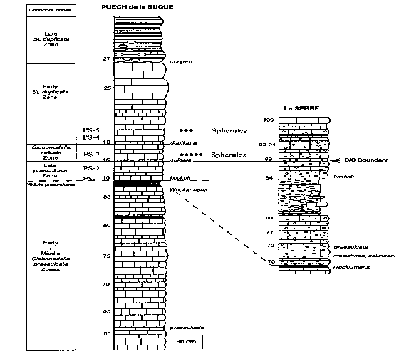
In August 1998 we carried out sampling in the stratotype area of the Devonian-Carboniferous boundary (La Serre, Montagne Noire, France), guided by Catherine Girard, Raimund Feist, and Francois Marini, as well as in the Puech de la Suque section of similar position. From the latter five samples were collected as follows:
PS-1 - Hangenberg shale (Upper Devonian); PS-2 - Light grey limestone, (Uppermost Devonian); PS-3 - Light grey limestone, (Lowermost Carboniferous); PS-4 - Grey shale (clay)(Lower Carboniferous), ; PS-5 - Light grey limestone, (Lower Carboniferous).
Applying 10% hydrochloric acid to the 100 g samples the insoluble residue was separated to two fraction : <0.063 mm and >0.063 mm. The magnetic fraction was extracted through magnetic separation. As a result, magnetic spherules have been revealed in two samples. In the PS-3 140, 5-50 micron spherules of black bright and mat surface was discovered, whereas the PS-5 sample yielded 16, 10-30 micron spherules of black mat surface. The spherule-bearing pelagic limestone of compact texture lies exactly above the Devonian-Carboniferous boundary, in the lowermost Carboniferous. Spherules are abundant in the PS-3 sample directly above the D-C boundary, whereas they occur only sporadically in the PS-5 sample upward the profile. The figure shows the stratigraphic position of the spherules.
References
Catherine Girard (1994) : Conodont Biofacies and Event stratigraphy across the D/C Boundary in the stratotype area (Montagne Noire, France) – CFS-Courier 168, pp.299-309.
___________________________________________________________________________
Meteoritic Impact Records and Early Crustal Evolution
A. Y. Glikson1
1
Research School of Earth Science, Australian National University, Canberra, ACT 0200Lunar mare and terrestrial crater counts, and the observed flux of Near Earth Asteroids (NEA) and comets define a consistent impact flux in the order of 4-6x10^-15 km^-2 yr^-1 within the inner solar system. These rates, coupled with observed crater size-frequency relation N~Dc^-1.8 (N = cumulative number of craters of diameter >Dc), imply the formation on Earth of over 450 craters Dc>=100 km, over 50 craters Dc>=300 km, and over 20 craters of Dc>=500 km since the end of the Late Heavy Bombardment (LHB) ~3.8 Ga. Geochemical and isotopic constraints require that oceanic crust occupied a time-integrated area of >>80% since the LHB. The identification to date of 3 craters Dc>=300 km on the continental crust (Vredefort,
Sudbury, Morokweng) implies a lower limit of 12 oceanic craters, as compared to 42 oceanic craters of Dc>=300 km predicted from the lunar crater and NEA fluxes.
Oceanic impact by projectiles Dp>=5 km result in excavation of lithosphere and adiabatic melting on scales comparable to Large Igneous Provinces (LIP). The largest impacts may be capable of localising and accelerating mantle plumes and ocean spreading centres, and the injection of shock energies >>108 TNT-equivalent by Dp>>10 km-large projectiles may, in
principle, result in propagating fractures and rift networks, thermal perturbations and ensuing magmatic activity. In view of the subduction of most of the pre-200 Ma oceanic crust, tests of potential correlations between large impacts and igneous and tectonic events require
identification and precise age determinations of distal ejecta, impact spherule condensates, meteoritic geochemical anomalies and possible contemporaneous igneous units, notably mafic dyke swarms.
Signatures of large early Precambrian impacts may be recognised in sediments and their metamorphosed equivalents.
Principal criteria include:
1. High-Ni (1-25% NiO) Cr spinels and trevorite-magnetite spinels documented in quench glass spherules (microkrystites) condensed from impact-vaporised meteoric-contaminated silicate vapour. These are found in 3.25-3.23 Ga sediments of the basal Fig Tree Group (Barberton Mountainland, South Africa), along the Cretaceous-Tertiary boundary, and in late Eocene and Pliocene impact-related Ir-enriched horizons.
2. Chondritic spinels of distinctly chrome-rich composition (YCr >= 0.8) denuded from chondritic material - as identified in the Isua supracrustal belt (southwest Greenland) and in the Jack Hills area (northwestern Yilgarn Craton, Western Australia).
3. Whole-rock relations between siderophile and lithophile elements. The absolute abundances and ratios of siderophile and transition elements may be diagnostic of meteoritic components. As Ni/Cr ratios of chodrites (~4) are distinct from the Ni/Cr ratios of ultramafic rocks (mostly <1), sediments including a significant meteoritic components may be identified.
For example, high Ni/Cr ratios in carbonaceous shales of the Mount MacRae Shale, Hamersley Group, Western Australia, commonly display high Ni/Cr ratios of up to ~ 5 - a potentially significant observation in view of Iridium anomalies observed in these sediments. Other potentially important discriminations may be offered by the Ti/P ratios, enriched in the mantle relative to chondrites by factor of about 30, and potentially observable in impact-related materials.
In 1998 the project involved the study of early Archaean sediments using the Scanning Electron Microscope, Energy Dispersive Spectrometry and Wavelength Dispersive Spectrometry. Samples include metamorphosed banded ironstones and detrital sediments from Western Australia and Greenland, and in a further stage will include sediments from the North-western Territories and Labrador.
References
Glikson, A.Y., 1998. Eugene Shoemaker and the impact paradigm in Earth science. Celestial Mechanics and Dynamical Astronomy, 69: 3-24.
Pirajno, F. and Glikson, A.Y., 1998. The Shoemaker impact structure, Western Australia. Celestial Mechanics and Dynamical Astronomy, 69: 25-30.
Pirajno, F. and Glikson, A.Y., 1998. The Shoemaker impact structure (formerly Teague), Naberru Basin, Western Australia. The Australian Geologist, March, 1998.
Glikson, A.Y., 1998. The astronomical connection of terrestrial evolution. The Australian Geologist, October, 1988.
Glikson, A.Y., 1998. Can shatter cones and penetrative deformation lamella form due to explosive volcanic processes? A discussion of "Argument supporting explosive igneous activity for the origin of "cryptoexplosion" structures in the mid-continent, United States. Geology (in press)
Glikson, A.Y., 1999. Oceanic mega-impacts and crustal evolution (in press).
Glikson, A.Y. and Kojan, C.J., 1998. Origin of the Mingar Dome, western Pilbara Craton, Western Australia: Field, multispectral and geophysical evidence, with reference to the search for Australian meteoritic impact structures. Geological Survey of Western Australian Annual Review (submitted).
___________________________________________________________________________
Multiple Archaean 3.26-3.24 Ga mega-impacts: correlated rifting and magmatic events, Pilbara Craton, Western Australia
A. Y. Glikson1
1 Research School of Earth Science Australian National University, Canberra, ACT 0200
Three units of spherulitic microkrystite condensates identified at the base of the Fig Tree Group, Barberton Mountain Land, eastern Transvaal [1], and characterized by marked PGE anomalies [1,2], quench-textured and resorbed Ni-rich chromites [3], Iridium nano nuggets [2], and 53Cr/52Cr ratios diagnostic of C1 chondrites [4] - define the oldest well-defined
mega-impact cluster in the Archaean record. These units include: S2 - 3243±4 Ma; S3, S4 - 3227±4 3243±4 Ma. Lowe and Byerly [1] perceptively remarked on the potential significance of the occurrence of these impact records along the boundary between the komatiite and basalt-dominated Onverwacht Group and the turbidite and felsic volcanic-dominated Fig Tree
Group and overlying conglomerates of the Moodies Group. 3.26-3.24 Ga events are widespread in the western Pilbara [5,6] and the central Pilbara Strelley-Soanesville belt [7-9]. In the latter, a volcanic and sedimentary sequence (Sulphur Springs Group - SSG) [8] consisting of komatiite, andesite and dacite is dated by U-Pb zircon within the range of 3.26 Ga [7] and 3238-3235 Ma [9]. Within the SSG stratigraphically low clastic sediments (Leilira Fm) contain conglomerate consisting of rounded quartz pebbles, angular chert fragments and silicified mm-scale spherules with fuchsite-rich centers. These sediments are overlain in places by up to 3000 meter-thick sequence of high-Mg komatiites (Kunagunarrina Fm - KF) and andesite-dacite assemblage (Kangaroo Cave Fm - KCF). The Sulphur Springs Group is overlain by chert, felsic volcanics including tectonic olistostromes, paraconformably overlain by a yet-undated sequence of siltstone-banded ironstone sequence (Gorge Creek Group - GCG) [8].
Preliminary reports of spherule-bearing fuchsite sediments at the base of the Gorge Creek Group remain to be followed up. The SSG is intruded by the comagmatic 3.24 Ga Strelley Granite. Equivalents of this intrusive phase are recognised within the Yule Batholith to the southwest [8]. As in the Barberton Mountain land, the 3.26-3.24 Ga Pilbara spherule units occur at stratigraphic levels immediately underlying major volcanic and tectonic developments, as follows: (1) below a major volcanic event including high-Mg komatiites (KF, KCF), and (2) below olistostromes and the base of a rift-type clastic sequence (GCG). The temporal juxtaposition between the multiple 3.26-3.24 Ga spherule units in the Barberton and Pilbara and the onset of major magmatic and rifting events is considered a test case for
the identification of potential genetic relationships between mega-impacts and Precambrian magmatic/rifting episodes. For spherule unit S4 - Cr and Ir abundance-based mass balance calculations suggest a chondritic projectile >30 km-diameter, implying cratering on the scale of >600 km-diameter, of probable oceanic setting in view of the lack of shocked quartz fragments [3,4 and this study]. Modelling of the effects of very large impacts on thin thermally active oceanic crust overlying shallow asthenosphere predict regional to global magmatic and tectonic effects consistent with the above observations [10].
References
1. Lowe, D.R., Byerly, G.R., Asaro, F. and Kyte, F.T., 1989, Geological andgeochemical record of 3400 m.y.-old terrestrial meteorite impacts. Science 245:959-962.
2. Kyte, F.T., Zhou, L., and Lowe, D.R., 1992. Noble metal abundances in an early Archaean impact deposit. Geochimica et Cosmochimica Acta, 56:1365-1372.
3. Byerly, G. R., and Lowe, D. R., 1994, Spinels from Archean impact spherules: Geochimica et Cosmochimica Acta, 58:3469-3486.
4. Shukolayukov, A., Kyte, F.T., Lugmair, G.W. and Lowe, D.R., The oldest impact deposits on Earth - first confirmation of an extraterrestrial component (abstract), Cambridge meeting on Impacts and the Early Earth.
5. Sun, S.S. and Hickman, A.H., 1998, New Nd isotopic and geochemical data from the West Pilbara - implications for Archaean crustal accretion and shear zone movement: Australian Geological Survey Organization Research Newsletter, 28:25-28.
6. Nelson, D.R., 1998, Compilation of SHRIMP U-Pb zircon geochronology data, 1997: Western Australia Geological Survey, Record 1998/2.
7. Vearncombe, E.S., Barley, M.E., Groves, D.I., McNaughton, N.J., Micucki, E.J., and Vearncombe, J.R., 1995, 3.26 Ga black smoker-type mineralization in the Strelley belt, Pilbara Craton, Western Australia: J. Geological Society of London, 152:587-590.
8. Van Kranendonk, M.J. and Morant, P.,1998, Revised Archaean stratigraphy of the North Shaw 1:100 000 sheet, Pilbara Craton: Geological Survey Western Australia Annual Review 1997-98, 55-62.
9. Buick, R., 1997, in Van Kranendonk and Morant, 1998 [9], p.58.
10. Glikson, A.Y., 1999, Oceanic mega-impacts and crustal evolution, Geology, 27:387-390
On the Cenomanian - Turonian boundary in Albania and the possibility for the spherule research.
J. Hoxha1 and F. Cara1
1 Albanian Geological Survey, Institute of Geological Research. Blloku "Vasil Shanto" Tirane, Albania
The Albanides are derived into External Zones, showing a continuous sedimentation ranging from Trias to Eocene, and Internal Zones that includes the Mirdita ophiolites, which were folded during the Jurassic and Cretaceous tectonic phases.
There is Upper Cretaceous (Cenomanian - Turonian boundary) in some Albania Geological Zones.
In the Korabi Zone - Turonian - Senonian age, thickness 80 - 150 m, conglomerate.
In the Mirdita Zone - Senomanian age, limestone, thickness 100 - 180 m, and Turonian - Senonian, compact limestone too.
In the Alpe zone - Cenomanian - Turonian, thicknees 50 m, shaly limestone.
In the Kruja Zone - Cenonomanian limestone.
In the Jonike Zone - Cenomanian - Turonian, crystalline limestone and laminated limestone 250 - 350 m. thickness.
In the Sazani Zone - Limestone of Turonian - Senonian age.
It seems that the Cenomanian - Turonian boundary is a very interesting geological episode in the Albania Region (Alpe and Jonike Zones).
In the some places is very important to investigate to Spherule Research.
In the Mediterranean Region (papers presented to the Annual Meeting of IGCP 384, 1998, Budapest, presentation of Colombetti - Nicolodi, Italy) the Cenomanian - Turonian transitions (impact event) is detected in Spain and Italy, too.
It would be an excellent think, if we could be able to find this event and in Albania.
We have collected about 30 samples from the sediments of Jonike Zone for the future spherule research.
No results until now.
I think to continue the sampling processes for the future results.
__________________________________________________________________________
Panther Mountain Buried Impact Crater Is Confirmed
Y.W Isachsen1
1
New York State Geological Survey/State Museum, Albany, NY 12230, yisachse@mail.nysed.gov; HANLEY, Kristy, Dept. of Earth and Atmospheric Sciences, University at Albany, Albany, NY 12222Panther Mountain, located in the Catskill Mountains, New York, is a circular mass, 10 km in diameter, defined by an anomalous circular drainage pattern. Earlier surface and gravity studies led to the conclusion that the circular valley reflects the rim of a deeply buried impact crater 10 km in diameter.
The nearest subsurface information is provided by well cuttings from the 2000 m-deep Herdman gas test well located near the northern edge of Panther Mountain. Some 660 bags of washed cuttings were examined microscopically for evidence of impact. Seven black magnetic spherules, measuring 200-950 micrometers in diameter were found in the Herdman well at the Middle-Upper Devonian boundary and three much smaller ones at the same stratigraphic position in the Armstrong well, one crater diameter distant. Most spherules retain a core of iron + nickel beneath an ablation rind of magnetite, and are clearly of cosmic origin. Their presence, combined with their decrease in size and number going outward from the structure, support the proposed model of a buried complex impact crater, but do not prove it. Current studies, however, confirm the existence of an "intact impact" beneath Panther Mountain. Seventy-five thin sections of quartz-rich layers in the Herdman and Armstrong wells were prepared to search for pressure deformation features (PDFs), which would prove impact. Examination of several thousand grains to date reveals numerous examples of PDFs. Initial thin-section study focused on the stratigraphic intervals where spherules had been found earlier in both wells. In the Herdman well, a 10 meter interval near the Middle-Upper Devonian boundary contains both PDFs and metallic cosmic spherules. PDFs and spherules are also found at this stratigraphic position in the Armstrong well. Thus PDFs exist in both the fallback zone and the fallout apron.
Inasmuch as the central fracture zone of the crater transects Lower and Middle Devonian strata, which contain numerous gas producing formations in central and western New York State, the structure possesses economic potential for gas production and storage.
___________________________________________________________________________
Geochemistry and Crystal Chemistry of Urban Waste Incinerator Ash. Avoidance of Environmental Pollution after Vitrification
P. Jobstraibizer 1, G. Molin 1, S. Hreglich 2, A. M. Fioretti 3, & R. Canale 1
1 Dip.to di Mineralogia e Petrologia dell’Università, C.so Garibaldi, 37 – 35137 Padova (Italy)
2 Stazione Sperimentale del Vetro, Murano (Italy)
3 CNR – Centro Studi Geodinamica Alpina, C.so Garibaldi, 37 – 35137 Padova (Italy)
Knowledge of the chemical-physical properties of ash produced after incineration of solid urban waste is essential for assessment of the long-term stability of such ash and thus its potential for environmental pollution. This work studied ash produced by the municipal incinerator of Padova (Italy) and the products of their vitrification. The latter process aimed at rendering the ash inert, for reduced environmental impact and, if possible, its use in the construction industry. Within the ambit of this study, first the nature and composition of crystalline and glassy phases were characterised, followed by investigation into their solubility, adsorption and thermodynamic stability. The vitrification process, carried out at the Stazione Sperimentale del Vetro on the island of Murano (Italy) yielded a more stable system than ash as regards the external environment.
The various study methods used (optical crystallography, SEM, EMPA, XRPD, XRF) characterised the grain size, chemical composition, element distribution and crystalline nature of the phases present in particulate. The most representative grain size was that of inhalable dusts (10-50 mm). The contemporary presence of both glassy and crystalline phases was observed, each characterised by different degrees of resistance to attack by external agents. The identified crystalline phases included soluble chlorides and sulphates, carbonates, allumosilicates, and Fe, Ca and Ti oxides. Heavy elements included high concentrations of Cd, Pb, Zn and Cr in carbonates. These concentrations represent a potential source of pollution, since ash remains in acid environments due to the release of heavy elements, once its original alkalinity has been lost. Examination of the analytical results and the thermal conditions inside the incinerator showed that volatile elements Pb, Cd and Zn underwent evaporation in the combustion chamber and later condensed on the surface of ash particulate in the incinerator areas in which the temperature was lower. This surface arrangement of heavy elements in solid particulate, in view of the high surface/volume ratio of the grains, considerably increases the extraction risks after ingestion and inhalation. This risk is associated with that of contamination of the watertable, in the case of dumping in landfills, due to possible superficial leaching of heavy elements.
Thus, unless it is rendered properly inert, ash produced by the incinerator may constitute a serious ecological and ecotoxicological problem. The inertization method used is that of vitrification). The process tested in the present work shows that, if 30% of feldspar flux, a material of practically negligible cost, is added to the ash, the result is the economic production of a glass with high resistance to chemical attack, as proved during leaching tests. The vitrification process thus has the following advantages: 1) reduction of the volume of ash, together with a great reduction in the surface/volume ratio per unit of weight, which in turn leads to retention of heavy metals condensing on the surface of ash grains; 2) vitrification as a result of a low-cost flux facilitates the melting process and makes it economically viable; 3) the low concentrations of extractable elements mean that the vitrified ash can be dumped in relatively inexpensive landfills
________________________________________________________
Magnetic fines from the Kaali impact-site (Holocene, Estonia) : preliminary SEM investigation
F. MARINI 1 , A. RAUKAS 2 and R. TIIRMAA 2
1
Ecole Nationale Supérieure de Géologie (E.N.S.G.). Rue du Doyen M.Roubault, BP40, 54501 Vandoeuvre-les-Nancy Cedex, France.
2
Geoloogia Instituut, Estonia Pst 7, EE-0100 Tallinn, EstoniaThe Kaali meteorite crater group lies 15 Km north of Kuressaare, island of Saaremaa, Estonia. The main crater -110 m in diameter, 20 m in depth-. Is surrounded by eight, much smaller, secondary craters (39 to 13 m in diameter), scattered over an area of ca. 1 sq. Kilometer.
The whole group is believed to derive from low-altitude disruption of an initial mass of 400-10000 tons, the fragments of which struck the ground obliquely (35-40°), from N-eastern direction, at a velocity of ca. 13 Km/sec. The mass of the largest fragment is estimated ca. 40-50 tons [1 and refs. therein]. Impact is older than 4000 BP, basing on recent radiocarbon- and pollen- datings of sediments infilling the craters. It might be as old as 7600 BP, according to indirect datings from surrounding marsh deposits [2].
Coarse impactor remains are extremely scarce (total recovered weight ca. 5500g, largest available fragment : 28.7 g). From these few remains, the impactor was ascribed to the IA group of coarse (Og) octahedrites, with an average composition of : 96.4% Kamacite; 1.8% Ni-rich Taenite; 1.7% Schreibersite-Rhabdite ; and minor amounts of Troilite and Olivine [1 and refs. therein].
In contrast, fine, impactor-derived particles are fairly abundant. Detailed regional mapping of sediments around Kaali showed high contents of Fe-Ni fines, including spherules and debris : from 10 to more than 30 g/m3 over an area of ca. 7000 sq. Km [3]. An overview of these particles was given by [4], from pioneering SEM investigations
In the present study, we focus on samples collected much closer to the craters, in order to minimize both possible contamination effects and age uncertainties. All samples come from either crater infillings (especially crater n°4), or from the crater field proper (1 sq. Km). We performed SE and BSE, 3D-examination, and EDS standardless analysis. Further studies will include sectioning and WDS quantitative analysis.
Four main kinds of particles were found, thereafter ordered from most- to less- evolved objects : I-Pre-impact spherules. These are large (200-350 microns) spherules –or spherule fragments-, with rugged surface, exhibiting dendritic patterns of large size and complex forms. Such patterns are usually ascribed to spherules derived from meteor ablation during atmospheric entry. They include : (a) conspicuous, "cob-like features" [5]; (b) aggregates of
magnetite octahedrons forming large needles, combs, and platelets (with triangular and quadrangular contours). Other features of pre-impact spherules comprise frequent central cavity, decorated with coarse dendritic forms, and thick shells also showing spectacular, coarse dendritic arrangments.
II-Magnetite spherules and splash-forms, from melted impactor. All these particles exhibit quite distinctive external features : smooth surface, showing much more delicate, and homogeneous textural patterns of dendritic Magnetite (either pure, or bearing variable Ni and Si). Conditions of surficial cooling obviously differed from those prevailing in pre-impact
spherules.
Two main types were found : (1) Small-sized (100-200 microns), impact-related spherules ascribed to the oxidized, metal spray produced by desintegration of meteorite body upon impact; ( 2) Larger splash forms (0.5-0.8mm), consisting of pear- or potatoe-like spatters from oxidized, molten impactor. Both types have internal gas vesicles, forming central voids and smaller cavities. These "bubbles" may outgas and pierce the external shell, or lead to distortion, explosion or shatter of the semi-molten particle. However, most shells still significantly remain thicker than those known in artificial spherules from industrial smokes (i.e., magnetic coenospheres). In contrast, extremely coarse and spectacular dendritic intergrowths of magnetite, may develop in interiors of large spatters, as normally expected from slower cooling within larger masses of magnetite melt.
III-Oxidized plates and platelets. Conspicuous, flat fragments are unexpectedly abundant in the Kaali matters. Leaving aside thin flakes simply derived from splash-forms just above, these belong to two groups :
IV-Deformed fragments still containing metal parts. These comparativley "pristine" impactor remains (0.5-2mm) consist of sandwiched layers of : (a) secondary oxides (1-20 microns thick); and (b) thin (1-5 microns), unaltered sheets of metal Fe-Ni alloy. Oxide layers are most complex aggregates, involving variable amounts of Hydroxides, Carbonates, Sulphates, Phosphates, and Oxichlorides, all resulting from alteration. Max. found contents (in W%) are : S : 8.4%; P: 5.4%; Cl: 2.45%. In addition to Fe, some oxide layers may bear high Ni (12 to 25 %), and high Cu contents (up to 3.7%). Occasional silico-aluminates, and some Ca-Mg carbonates, both probably result from contamination from embedding sediments. Occurrence of Cl-bearing oxides (up to 2.45 % Cl) is more puzzling. It echoes anomalous Cl-contents of organic coatings around some spherules. This unexplained Cl might record temporary occurrence of saline pore-waters in the embedding sediments. By contrast, remains of metal sheets are far more simple : we found both sheets of Kamacite (4.6%Ni) and sheets of Taenite (Max Ni found so far : 34.2 %). All these sandwiched fragments bear strong imprints of deformations induced by impact : (a) Intense shearing and lineation of metal sheets, probably due to initial stress upon impact ; (b) Less penetrative deformations that postdate shearing, producing variably torn, buckled, folded and twisted fragments.
Such late-stage deformations probably result from secondary processes acting on shattered fragments, just after impact (i.e, stresses and shocks, within moving masses of ejecta).
All the above categories may bear coatings and infillings, of two main types : (1) Homogeneous surface coatings of organic matter, containing Cl, K, and variable amounts of Ca, Na and Mg (with minor P and S). This matter might originate from organic compounds in embedding sediments, or –most probably- derive from contamination from mounting glues. Some other coatings, clearly derive from mounting media (Na silicates). (2) Silt-like matter, still adhering on the surface of many particles, and infilling most voids (gas vesicles). Main components are K-Feldspar, Quartz, Micas, and extremely fine products (Clays, Feldspars, Dolomite, and Wads).
In conclusion : Fine particles from Kaali include boh impactor remains, and a complete sequence of impactor- derived products. Kaali fines thus record an extremely wide range of air-flight-, impact-, and post-impact processes.
They should provide an excellent probe into chemical- and isotopic- fractionation of elements over this whole range of processes. They seem particularly promising for further study of mass-dependent isotopic fractionation upon heating and evaporation [6], especially regarding: (a) Fe and Ni, and (b) O, subsequent to high-altitude flash-oxidation.
References
[1] Czegka, W. and Tiirmaa, R., 1998- Aufschluss, Heidelberg, 4 9,233-242; [2] Raukas, A., 1997- Sphaerula, 1, 1, 32-41; [3] Raukas, A. and Tiirmaa, R., 1995- Proc. Int. Meet. "Spherulites & (Palaeo) Ecology", Debrecsen, March 2-4 1995,. 29-39; [4] Schymanovich, S., et al., 1993- Proc. Estonian Acad. Sci. Geol., 42, 3, 127-133; [5] Marini, F., et al., 1997- Sphaerula. 1, 1, 4-19; [6] Engrand, C., et al., 1998- LPSC XXIX, 1473-1474.
___________________________________________________________________________
Texture and composition of extraterrestrial spherules from recent Atlantic and Pacific sediments
G. Molin 1, A.M. Fioretti 2, P. Guerriero3, M.V Dekov 4 & C. Griggio1
1 Dip.to di Mineralogia e Petrologia dell’Universita’, C.so Garibaldi, 37 - 35137 Padova (Italy)
2 CNR - Centro Studi Geodinamica Alpina, C.so Garibaldi, 37 - 35137 Padova (Italy)
3 CNR – ICTIMA- C.so Stati Uniti, 4 35020 Padova (Italy)
4 Dept. of Chemistry, University of Antwerpen. 2610 Antwerpen (Wilrijk) (Belgium)
Sample location: The samples from which the examined spherules were separated come from five different drillings performed in the sedimentary cover of the Mid- Atlantic Ridge, 26° lat. N, in an area between the transforms "Atlantis" (north) and "Kane" (south), and from twenty different drillings performed on sediments along the axial zone of the East Pacific Rise, about 21° lat. S. Samples from the Atlantic Ocean were collected during the XV oceanographic cruise along the "Trans-Atlantic Geotraverse" (TAG) by R/V Akademik Mstislav Keldysh. The TAG is one of the first active hydrothermal systems found in a mid-oceanic ridge with a low rate of expansion (1.1-1.3 cm/y). The age of the oceanic crust is 100,000 years. The overlying drilled sediments are composed of foraminiferal muds interbedded with metalliferous sediments and layers rich in basaltic clasts.
Samples from the Pacific Ocean were collected during the IV oceanographic cruise by R/V Geolog Fersman (VNIIO keangeologiya, St. Peterburg). The sampling area lies between 20°30’S and 22°10’S, between two overlapping spreading centers. The East Pacific Rise is an ultra-fast-expansion ridge (7-9 cm/y). The sampled sediments represent the cover of the oceanic crust. They consist of a great variety of stratified, highly oxidised, metalliferous calcareous muds containing Fe-Mn oxides and hydroxides, hyaloclastic fragments, aeolian material and biogenic limestone (foraminifera and coccoliths).
Sample preparation and analytical techniques: sediments from the drilling cores were washed with distilled water to remove soluble salts, and sieved at various granulometric fractions. Fractions between 1 and 0.001 mm were studied under the stereomicroscope, and observed spherules were separated by hand picking, yielding 18 spherules from the Atlantic samples and 19 from the Pacific ones. The spherules were first observed under a Scanning Electron Microscope (coupled with the EDS system) for preliminary morphological study. Each spherule was then mounted in epoxy resin, polished to the equatorial plane, and analysed by WDS Electron Microprobe.
Results: Based on their morphological characters and mineralogical composition, the spherules were divided in three groups: magnetic, silicatic and vitreous.
The most abundant spherules (55%) are magnetic and consist of Fe-Ni alloy, either as metal or as oxide. They sometimes contain Al, Si and S in minor quantities. Two spherules contain an Fe-Ni core (Ni up to 49 wt. %) and a have dendritic shell made up of magnetite and wunstite with minor Ni content. Three spherules are composed of a void shell of dendritic Fe-oxides, without the Fe-Ni core. The morphological characters and chemical composition of these five spherules are fully consistent with the genetic model proposed by Dong Bi et al. (1993). The remaining 15 magnetic spherules are composed of magnetite and/or hematite with Ni up to 0.5 wt%, sometimes with traces of a dendritic texture.
The silicate spherules (40%) are composed of varying amounts of olivine, skeletric magnetite and corroded interstital glass. Olivine crystals are often zoned with forsteritic cores (Fo up to 99%) and more fayalitic rims (Fa up to 64%). Compositional zoning is consistent with heating of crystals at temperatures as high as 1500-1900 C, followed by rapid quenching. Based on their external and internal morphologies, these spherules were subdivided in four groups: 1 - spherules with vacuoles 15-75 microns in diameter located both on the surface and inside the spherules. They are composed mainly of olivine, with minor amounts of dendritic magnetite. The vacuoles are interpreted as due to degassing of volatile elements such as S in sulphurs or ice of volatile substances (Parkin & Sullivan, 1977; Blanchard et al., 1980); 2 - Magnetite and olivine making up a typical "brick texture", in which the bricks are composed of olivine crystals cemented by smaller amounts of dendritic magnetite; 3 - The external part of these spherules shows a faint "brick texture"; the back-scattered images of polished equatorial planes reveal a fine weft of dendritic magnetite crystals with interstitial fayalitic olivine and glass; 4 - these spherules are composed of resorbed, zoned olivine crystal cemented by a glass of olivine composition, neither of which have good stoichiometric composition. Small "needle-shaped" crystals are evident in the matrix of some spherules, indicating a fast growing of crystals followed by rapid quenching.
The vitreous spherules (5%) have a quite homogeneous chemical composition, with high Si, Al and alkali contents, consistent with terrestrial volcanic ashes of dacitic composition. As their extraterrestrial origin is very unlikely, they are not included in the following discussion.
Data from the literature report that magnetic spherules collected in oceanic sediments are much more abundant (25-50% of the whole spherules) than those recovered from melting ice in Greenland (2-3%). This indicates that natural processes acting in deep oceans are much more effective in concentrating magnetic spherules than silicate ones. The low percentage of silicate spherules is due to their dissolution by aggressive marine water, mainly in active hydrothermal environments. Further "secondary" enrichment of magnetic spherules may occur when the spherules are collected in loose sediments by mean of magnetic devices, which is not the case of the present study.
In our study, all the Atlantic spherules are magnetic, whereas only 25% of the Pacific group are so, the remaining 75% being of silicate composition. This is consistent with the specific chemical-physical environments of the sediments from which the two groups of spherules were separated.
References
Blanchard M.B., Brownlee D.E., Bunch T.E., Hodge P.W., & Kyte F.T. (1980) Meteoroid ablation spheres from deep-sea sediments. Earth and Planet. Sci. Lett. 46, 178-190.
Dong Bi, Roger D. Morton and Kung Wang (1993) Cosmic nickel-iron alloy spherules from Pleistocene sediments, Alberta, Canada. Geochim. Cosmochim. Acta 57, 4129-4136.
Parkin D.W. & Sullivan R.A. (1977) Cosmic spherules as rounded bodies in space. Nature 266, 515-517.
___________________________________________________________________________
Investigation of Impact and Extraterrestrial Spherules in the Kaali Area (Island of Saaremaa, Estonia) for the purposes of Regional Stratigraphy.
Raukas, A.1
1
Institute of Geology at Tallinn Technical University, 7 Estonia Avenue, Tallinn 10143, Estonia, E-mail Raukas @ gi.eeDuring the last one hundred years microscopic glassy and ferroic spheroids of different origin have often been found in various geological formations, both in the bedrock and Quaternary cover.
The author’s main interest has centered on the Estonian Holocene craters. In and around the Kaali craters in the SE part of Saaremaa Island the soil contains a large number of micrometeorites and pulverized impactite matter. The mighty explosion with accompanying high temperature led to the formation of glassy silicate spherules which distributed over a large area in Saaremaa and Hiiumaa, allowing to estimate the age of the impact at about 7500 years BP and correlate rather far-lying sediments.
The extraterrestrial and explosive material in the Kaali area is very rich in forms and colours. Three main groups – meteoritic iron, meteoritic dust and microimpactites – exist.
Meteoritic iron. Iron pieces were formed as a result of the break-up of the meteorite in the atmosphere. Due to its disintegration at the moment of impact it is represented with irregular tiny meteorite fragments and fine (less than 1 mm) pulverized particles, which display a variety of shapes. They are highly oxidized and crusted with a thin layer of loamy material. Probably, a large part of the meteorite’s material was lost due to oxidation.
Meteoritic dust. If a meteorite enters the Earth’s atmosphere and rapidly begins upheated, partly melted and evaporated, a lot of microscopical particles fall down, covering huge areas. The products of evaporation are represented with magnetite globules and platelets varying in shape, internal structure and microsculpture (Shymanovich et al. 1993). Globules may be spherical, rounded elliptic, ovatetubercular or drop-like. In terms of the internal structure, hollow globules and compact globules with a metallic nucleaus exist. On the surface of some nuclei distinct Widmänstatten structures occur. Dull grey platelets usually have a metallic lustre. They are less than 1000 m m in diameter and 100…120 m m in thickness. There is a characteristic pattern of rhombs, quadrangles and polyhedrons on the surfaces of spherules.
Microimpactites formed on the melting and vaporization of meteoritic matter and target rock during the impact are usually brownish-yellow with smooth lustrous surfaces, pitted with odd furrows. Both magnetite-silicate and silicate formations have been found. Around the craters, the concentration of magnetite-silicate formations reaches several hundred mg per cu. M. The largest subspherical, drop-like or ellipsoidal magnetite-silicate formations have a diameter of 600 m m. The diameter of silicate globules ranges from 5 to 20 m m.
Glassy spherules were selected under a binocular microscope from the ash left after the burning of peat. The spherules were determined one by one by means of electron microprobe analysis. The chemical composition of glassy microimpactites is diverse. In the Kaali crater field, some spherules consist mainly of silica and calcium with a small admixture of iron, others are prevailed by calcium and iron, while the third ones consist of silica with a small quantity of calcium, iron and nickel. Some spherules are extremely rich in nickel, containing at the same time also Co and Ti.
___________________________________________________________________________
Spherules and Senonian formations in Hungary
A. SIEGL-FARKAS1
1
Geological Institute of Hungary, H-1143 Budapest, Stefánia-út 14, e-mail:siegla@mafi.hu"Spherules found in deposits of different ages may be indicators of the geological- and/or extraterrestrial events" Hungary is divided for two megatectonic units (Pelso and Tisza) what were situated relatively far from each other in the NW edge of the Tethys still during the Late Cretaceous.
Spherulite contains Senonian formations have been studied in the Pelso Unit where they can be found in two different facies realm.
The Senonian sediments in the Transdanubian Central Range represent a classical trangressional succession where on the older Mesozoic rocks are deposited the freshwater (Csehbánya- and Ajka Coal Formations) and than the both vertically and horizontally most extended marine formations (Jáko Marl-, Ugod Limestone and Polány Marl Formations).
Spherules both the glassy and magnetic were found in the all formations, except in the limestone ones.
By the integrated paleontological examinations the listed formations were ranged to the Santonian-Campanian age. The S/C boundary was marked in the lower part of the Jáko Marl and the top of the Polány Marl may belongs to the Maastrichtian-near sediments.
In the Nekézseny Conglomerate Formation (N Hungary) some glassy and magnetic spherules were found too.
Microsonda examinations carried out on the glassy spherules did not serve evidences for the extraterrestrial origin but the magnetic results based on the Ti contain can not close out that fact.
_________________________________________
Discovery of glassy microspherules at the top of Irati shales (Upper Permian) at Montevidiu (Goias, Brazil) comparison with the microspherules found at the impact cratering of Araguainha (Mt, Go, Brazil).
J.M. Thery1, P. Solt2, P. Crosta3,
1
9 Jardin Gabrieli, Tours, France.2
Geological Institute of Hungary, H-1143 Budapest, Stefánia u. 14.3
Unicamp, Campinas SP, BrazilWe worked about the field sections at Montevidiu, Alto Garcas, and at Araguainha, along the trail mt100.
The geological and biostratigraphical sequences are similar and well dated; They belong to the Corumbataï - Piramboia or to Terezina formation of upper Permian. At Araguainha the Fe=Si microspherules, fond from the impact breccias with melt matrix, near a shatter cone, are Tatarian, may be Changxingian, when the glassy microspherules at Montevideo are Kazanianto Kougurian and correlable with South Africa sequences.
The extraterrestrial events of the upper Permian are believed diversified in several alternative stages of geological time. Those later would be linked to several warmer steps of climatic changes, and to progressive disappearances of a lot of animal and vegetal species, before the catastrophic final event at the limit upper Permian/upper lower Triassic; at the time appears a new vegetation and the first most primitive dinosaurs, adjusted at a drier and even some desertic areas, according to discoveries at Santa Maria (RS).
The sedimentological and electronically microprobes studies show that evolution, during the geological sequence at Araguainha as at Montevideo; but further thorough studies with isotopes measurements, should be probably necessary, before complete results, that are in progress, with a definitive evidence of a meteoritic event in a complex occurrence.
References
A.P. Crosta et al. (1981). Revista Brasileira de Geocencias, H3 139 - 146.
W. von Engelhardt et al. (1992). Meteoritics, 27, 442 - 457.
A. Erichsen e J. Miranda (1939) Bol. N° 94 Serv. Geol. e Miner.
A. Erichsen e Loforen (1940) Boll. N° 102 Dito
V.J. Fulfaro (1971) Tese de Livre Docencia IG-USP, Bol. de Eng. Sao Carlos, 14, 112 pp.
V.J. Fulfaro (1972) An. Acad. Brazil; Ciencias 44 suppl., 147, 148.
R.M. Rohn (1994) Tese de Doutouramento; 376 pp., Sao Paulo.
R.M. Rohn (1993) 1 Simposio sobre chronostratigrafia do la bacia de Parana, Rio Claro, SP.
B. Theilen - Willige (1981) Clausthaler Geowissenschaftliiche Dissertation. HH 8 210 S., 116 Abh., 10 Tab. Clausthaler Zellerfeld.
J.M. Thery (1998) Annual Meeting of ICGP 384, Budapest, Hungary
J.M. Thery (1999) 14 Journee thematique des Geologues du Permien, 18 Juin 1999, Paris, Colegio de Espana, abstract 2p., 19-19
___________________________________________________________________________
Finland and Estonia Impact Craters - Excellent Spots for a Field Trip
I. Vetvicka1
1
Charles University, Department of Geology, Pøevoznická 14 , 143 00 Prague 4 Czech Republic , e-mail: vetvicka@mail.natur.cuni.czBack in 1997 I had the opportunity to study impact craters of Finland and Estonia.
I have obtained a grant for this project from the ZIS Foundation.
I was able to participate at the International Symposium (an IGCP Project Number 384) in Estonia thanks to a generous support from the Organising Committee.
I have collected specimens inside the following impact craters: Kaali, Ilumetsa, Lappajärvi, Kärikkosekä and Lumparn.
There is a total weight of valuable samples of 140 kg. I am examining them and my results are going to be published.
In the Lumparn Crater I have found some shatter cones and breccias.
There is a possibility the breccias could be formed as tectonic breccias = not formed by a collision, impact of a meteorite.
Preliminary results will be presented as a report with figures at the International Workshop Meeting IGCP 384.
___________________________________________________________________________
FIELD TRIPS GUIDE
The Pietra di Bismantova Stratigraphy: example of an Epiligurian Satellite Sedimentary Basin
Leaders: Alessandro Colombetti1 and Nicolodi Francesco2
1Prof. Alessandro Colombetti
University of Milano – Bicocca
Department of Geological Sciences and Geotechnologies
Via Mangiagalli, 34 Milano – ITALY
2
Dr. Nicolodi FrancescoUniversity of Milano
Department of Earth Sciences
Via Mangiagalli, 34 Milano - ITALY
Wednesday, September 8, 1999
14.30 – Departure: Castelnovo ne’Monti
15.00
STOP 1 – The Pietra di Bismantova
Along the way to the place, on the left, there are good outcrops of the Antognola Formation (upper Oligocene – lower Miocene). Here it’s possible to see the shales member. In this member, but in other localities, are found the terrestrial spherules of barium sulphates.
From the Eremo place there is a spectacular view of the cliff of Pietra di Bismantova, made from grainstones and boundstones of upper Burdigalian (?) – Langhian, here with a tickness of over 100 meters.
Here we can see the base of grainstones, with a layer of methamorphic cobbles (Serpentinites, calceschists and slates), in stratigraphical contact with the lowermost marlstones of Antognola Formation [fig. 1].
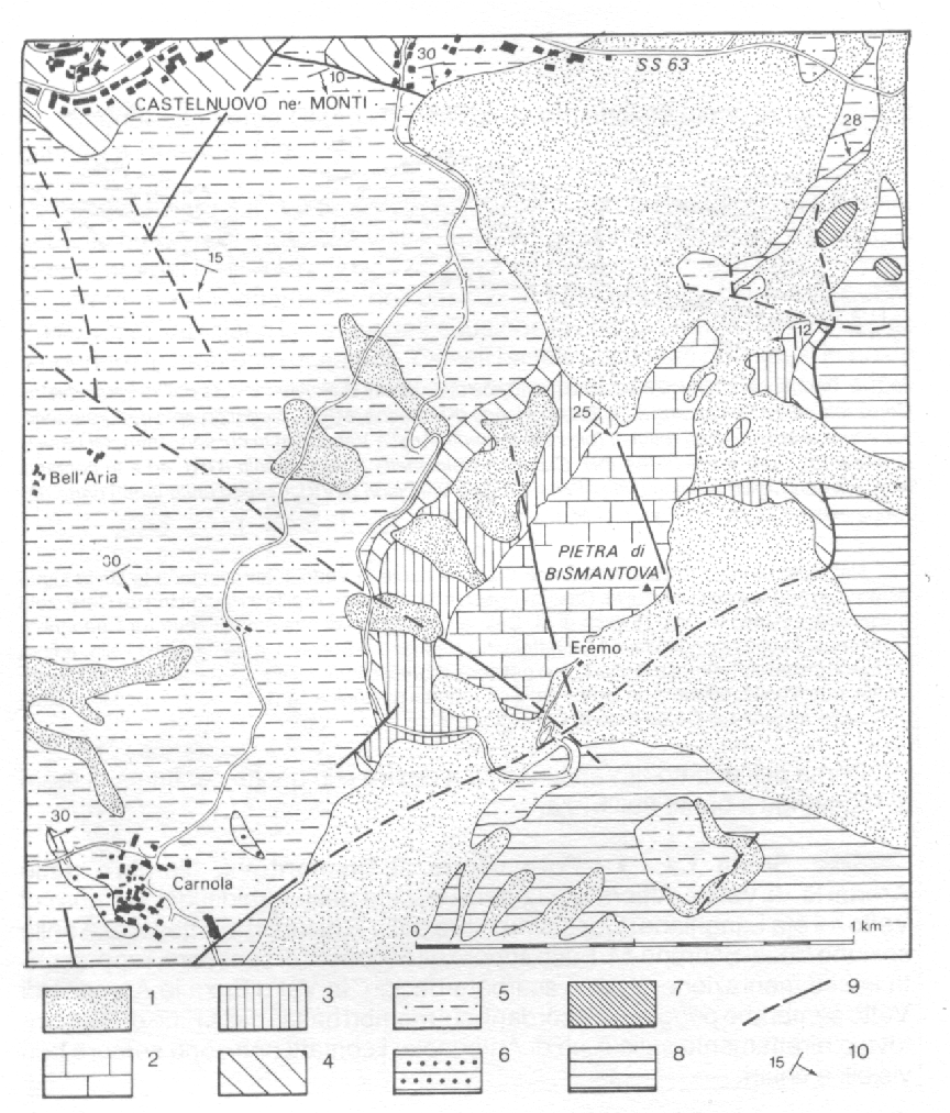
Figure 1 = Geological sketch map of the Pietra di Bismantova area. (1) Quaternary sediments; (2) Grainstones of Pietra di Bismantova; (3)Antognola Formatio, marly member; (4) Antognola Formation, "Marne dell’Antognola" member; (5) Ranzano Formation, shaly lithofacies; (6) Ranzano Formation, sandstones lithofacies; (7) Helmintoid Flysch; (8) Caotico Formation; (9) Faults; (10) Bedding. From AA. VV. (1992), modified.
Starting from the Eremo, along the track for the top of the cliff, we can see, for some hundred of meters, the contact between the basis of grainstones of Bismantova and the Antognola Formation. There are many fossil fragments of Echinoderms, Algae, Corals and Lamellibranchiata, typical of a low sea.
From the top of the Pietra di Bismantova we can see the Apenninic chain with its geological structures.
Stratigraphy of the K/T boundary and the Late Eocene impact events at Monte Cònero
Leader: Alessandro Montanari1
Thursday , September 9, 1999
9:40
STOP 1 Sedimentology of the K/T interval in the Poggio quarries
The Monte Cònero is the eastermost anticline of the northern Apennine thrust-and-fold belt. The lowermost formation exposed on the nearly vertical eastern limb of the anticline is the Lower Cretaceous Maiolica. The Aptian-Albian Marne a Fucoidi, Cenomanian Scaglia Bianca, and the Senonian Scaglia Rossa are missing in this area due to a hiatus.
The rest of the Campanian to Eocene Scaglia Rossa is well exposed in sea cliffs, and in several abandoned limestone quarries.
The Scaglia Rossa of Monte Cònero has a facies different from the equivalent unit of the classic Gubbio sequence. First of all, the Cretaceous portion of this formation exhibits a whitish-beige colour instead of the typical pink of the Umbrian facies, and secondly, coccolith-foraminiferal pelagic limestones are here interbedded with white calcarenitic and calciruditic turbidites derived from a carbonate platform, which was located not far to the east of the present Cònero area.
The K/T boundary is exposed in the lower Fornaci quarry face (Fornaci West Section), near the village of Poggio di Ancona (Fig. 1).
Approaching the quarry face is dangerous due to rock fall, and therefore it has to be observed from a safe distance.
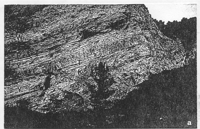
Figure 1 = The Fornaci West quarry face exposing the K/T boundary.
The K/T boundary is located about 80 cm below a 3 m thick calcirudite marker bed called the Marchesini Level or MegaT, and is marked by a 18 mm greenish clay layer sandwiched between pelagic limestones. A part from their whitish colour, the texture and microfacies of these limestones (i.e. the top Cretaceous mayaroensis limestone, and the basal Tertiary, porcellaneous eugubina limestone) are identical to those in the classic Gubbio sections. The whitish colour is due to a relatively reduced state of the paleoseafloor in comparison with the well oxygenated, abyssal environment in the Gubbio and Furlo areas. Higher planckton productivity and upwelling in this proximal environment may have been the main reasons
for more reduced conditions on the seafloor in respect to other open sea, deeper areas of the paleobasin.
The K/T boundary is well exposed, and easy to reach, in the Fonte d'Olio quarry, which we will visit in Stop 4. For the moment, we will take a closer look at the Cònero Scaglia facies in the upper level of the Fornaci quarry.
10:00
STOP 2 Fornaci Central and East Sections
On the way to the upper level of the Fornaci quarry, we will stop for a minute in front of a small quarry face where the K/T boundary is exposed. In this outcrop, the MegaT is not present, and the K/T boundary falls within a genuinely pelagic interval. On the other hand, a thick calcarenite layer is found in the top part of the outcrop (M. pusilla pusilla Zone). The absence of the MegaT, and the presence of this second massive calcarenite, and viceversa in the Fornaci West outcrop, indicate that these calcareous turbidites are strongly channelled, thus are laterally discontinuous (see stratigraphic correlation in Fig. 2).
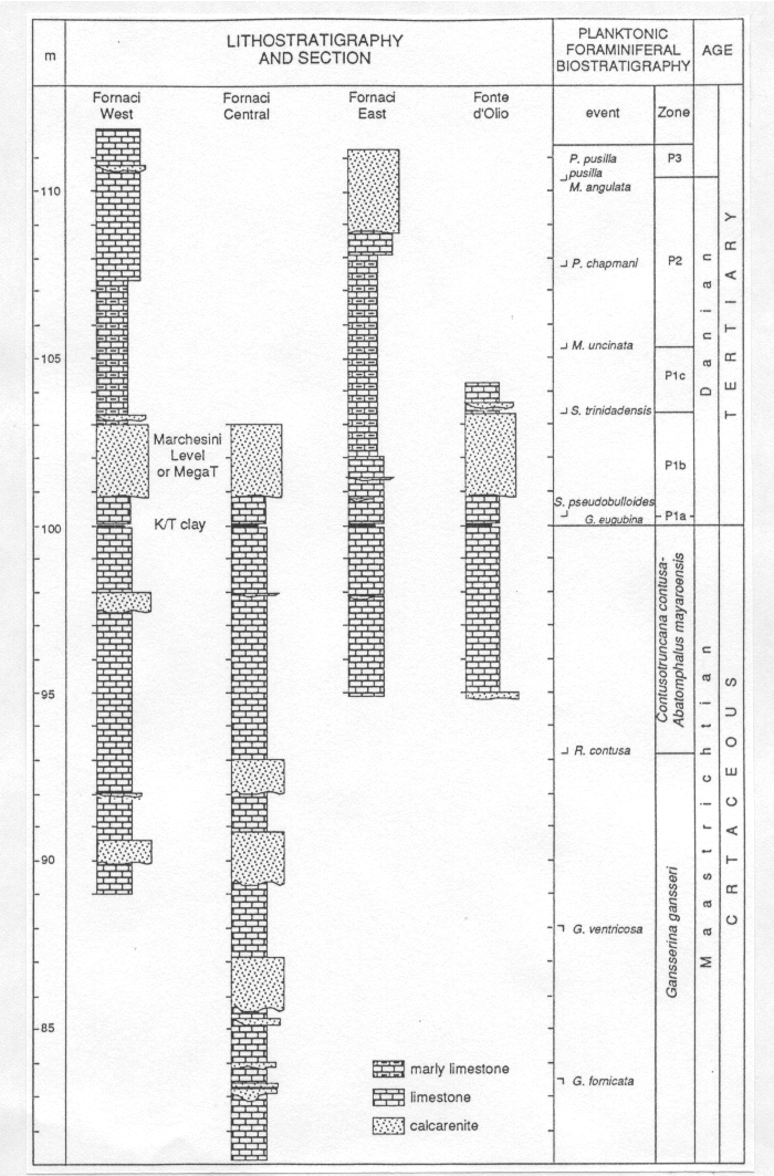
Figure 2 = Stratigraphy of four representative sections in the Cònero area covering the K/T boundary.
In the upper quarry outcrop (Fornaci Central Section), several of these calcarenitic turbidites are exposed below the MegaT. Some of them have clear erosional bottoms and are channelled; others exhibit a flat base, and an upward convex top surface: these represent lobes of calcareous debris interfingered with the abyssal pelagic sediment.
A closer look at these calcareous turbidites reveals a granular texture made of biogenic debris. Orbitoids, rudist fragments, calcareous algae, pieces of corals, and lithoclasts of pre-existing shallow water limestones are the main constituents of these turbidites, and indicate that they were derived from a dismantling carbonate platform. These detritic layers are found below and above the K/T boundary, and my represent excellent material for studying the biofacies evolution of the western Adriatic platform which was completely disrupted after the K/T event.
In simple words, they may function as messengers of an evolving, and eventually killed platform, the incomplete remanence of which is now buried under the Adriatic sea floor.
Large flutes and inclined laminations indicate a preferential paleocurrent flow from East toward West. Some large flutes with different shapes (i.e. bulb, tongue, and curl), are exposed at the base of some MegaT boulders piled up at the edge of the quarry ledge.
The K/T boundary is exposed on a ledge in the upper part of the outcrop, about 80 cm below the MegaT. It is not safe to climb up there to see it. Therefore, we will move on to the next stop, in the Fonte d'Olio section where the K/T boundary is well exposed and easy to reach.
11:00
STOP 3 The K/T boundary at Fonte d'Olio
In the upper part of the Fonte d'Olio valley, in the so-called Quagliotti Quarry, the K/T boundary exhibits the exact same facies as in the Fornaci quarries (Fig. 3). However, the Tertiary Scaglia shows a whitish colour indicating that in this part of the Cònero basin, reduced conditions on the sea floor lasted for several million years after the K/T event.
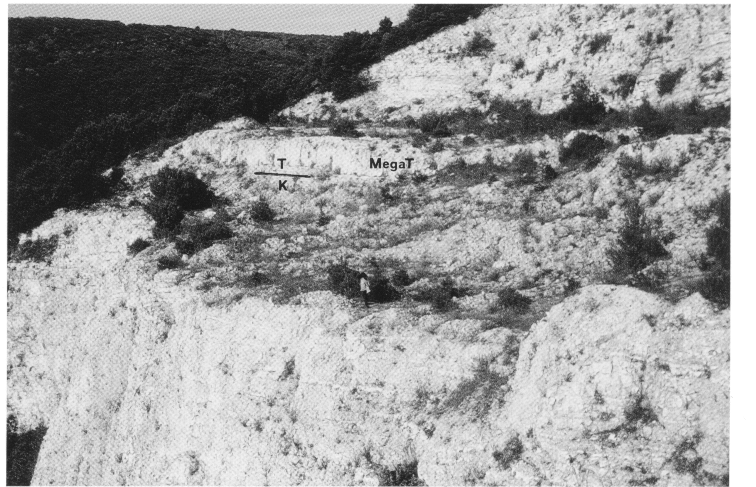
Figure 3 = Panoramic view of the Fonte d'Olio K/T section in the Quagliotti Quarry.
Here we can observe the K/T boundary from up close (Fig. 4). The clay layer exhibits a green-ochre colour and is therefore different from the same (red) layer observed at Gubbio and Furlo, and anywhere else in the Umbria-Marche basin. Bioturbation in the top layer of the Cretaceous, usually represented by abundant traces of Zoophycos and Planolites burrows in the classic, well oxygenated facies of Gubbio, are very scarce at Monte Cònero, possibly indicating slightly reducing conditions at the water-sediment interface.
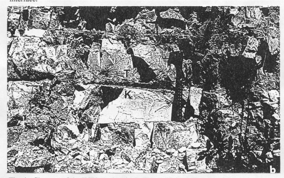
Figure 4 = Close-up of the K/T boundary in the Fonte d'Olio section.
Reducing conditions of the paleoseafloor are also indicated by the fact that goethite (i.e., iron oxide) spherules are absent in this K/T boundary layer. Only altered microkrystites made of immature, pale-green glaucony, and K-feldspar are present, along with shocked quartz grains, and well differentiated arenaceous benthonic foraminifers, which are somewhat bigger than those found in other K/T boundary layers in the region. Moreover, the boundary clay contains 10 ppb Ir, the largest anomaly measured in the Umbria-Marche basin (Montanari, 1990). Perhaps the K/T boundary of Monte Cònero is the best preserved in the Apennines despite the fact that its facies is different from the classic Gubbio (or Petriccio) facies.
The Terminal Eocene Events: an Introduction
In the years immediately following the publication by Alvarez et al. (1980) of the hypothesis that the impact of a giant extraterrestrial object was the cause of the K/T boundary mass extinction, an obvious question crossed the mind of those researchers who found such a hypothesis at least interesting: are there other mass extinction events throughout Earth's history that could be related to impacts?
It was with this question in mind that Alvarez et al. (1982) undertook a trace element geochemical investigation across two interesting stratigraphical boundaries, namely the Permian-Triassic (P/TR), and the Eocene-Oligocene (E/O). The first records the most severe Phanerozoic mass extinction, whereas near the latter, in some Caribbean and Gulf of Mexico deep sea cores, glassy microspherules were known to exist, and they were already recognised as impactoclastic material (see review in Montanari et al, 1993, and references therein). Moreover, with the first compilation and analysis of a data base and the plotting of marine families extinction rates through the past 250 Ma, Raup and Sepkoski (1982) showed that, in addition to the K/T boundary, there were some other ten statistically significant extinction peaks through this span of Earth history, and one of them was, in fact, at or near the E/O boundary. While the P/TR boundary yielded no Ir anomaly, the samples from the microspherule layer near the E/O boundary contained up to 0.4 ppb Ir. This was one order of magnitude less than the K/T boundary, but undoubtedly a strong indication that an anomalous accretion of extraterrestrial matter occurred at that time (Alvarez et al., 1982). These coincidences (Ir, microspherules, and mass extinction) were rendered even more intriguing by the fact that the largest impact structure in the past 250 Ma record known on Earth in the early 1980s was the 100 km-diameter Popigai crater, in central Arctic Siberia. Early radioisotopic dates were indicating an imprecise age of 39 ± 9 Ma for the Popigai structure, thus, covering the long stratigraphic interval between the Middle Eocene to the Early Oligocene. The whole picture of the terminal Eocene events in the early 1980s was somewhat out of focus compared to the controversial but undoubtedly exciting, emerging story of the K/T boundary. That the Late Eocene was a time of major change in Earth's history was felt by many researchers (see Pomerol and Premoli Silva, 1986). During the Eocene, the separation of Antarctica from the southern continents led to the formation of the circum-Antarctic current and the gradual glaciation of the continent. As the Antarctic polar ice cap spread until reaching the ocean, cold water masses formed along the continent's coasts. Being denser than warmer surface waters, these cold water masses started to sink moving away from the isolated continent for long distances toward North, eventually changing water circulation and temperature in the Earth's oceans. With time, the glaciation and a renewed oceanic circulation affected climate. Climatic cooling began to affect productivity of abyssal organisms as well as the plankton, and eventually altered the equilibrium of the global ecosystem. The global cooling model, so strongly supported by geologic, geochemical, and tectonic evidence, was a classical example of gradualism, which could stand by itself, and explain the observed global changes without having to invoke a catastrophic extraterrestrial event. Moreover, there was neither discrete boundary clay nor a dramatic extinction of dinosaurs (or of anything else) across the E/O boundary that could really attract the attention of the earth science community toward a possible extraterrestrial cause (or con-cause) for these events. And yet, impact evidence near the boundary were already available since the early 1970s. This was enough to encourage a few researchers to investigate further on these impact signatures.
One of the most hampering factors against a prompt development of research on the possible cause-and-effect relationship between impacts and mass extinction near the E/O boundary was, since the very beginning, a somewhat confusing stratigraphic and geochronologic calibration of this time interval. In fact, ages ranging between 36 and 34 Ma for the North American tektites, to which the Caribbean and Gulf of Mexico microtektites are related, were determined by fission track and K/Ar dating by a number of researchers. On the basis of biomarkers, the microtektites in Caribbean and Gulf of Mexico cores were assigned to the upper Eocene NP18 (nannofossil) Zone or to the P15 (foraminiferal) Zone is some cores, and to the NP19 Zone or P16 Zone in others. Further accurate 40Ar/39Ar dating of microtektites and tektite fragments from a land-based section in Barbados yielded an age of 35.4 ± 0.6 (Glass et al., 1986). The confusion was that the chronostratigraphic time scales most used in the early 1980s were assigning an age around 37 Ma to the E/O boundary and, therefore, they were in contrast with an age of 34.7-36 Ma for the microtektites, which were apparently contained in upper Eocene sediments. In other words, on the basis of geochronology the impact that generated the tektites and microtektites occurred in the lower Oligocene but microfossil associated with them indicated an upper Eocene age.
Such stratigraphic and geochronologic uncertainties did not help in searching the needle in the haystack. Precise and accurate means for world wide time correlation are the sine qua non for assessing the uniqueness of a sudden event such as an impact, and locate it within the stratigraphic-paleontologic record. Moreover, the time correlation between marine sediments and an impact crater, upon which any kind of inference on a possible cause-and-effect relationship can be drawn, has to be based on numerical geochronology, and, therefore, on a reliable radioisotopic calibration of the time scale. The problem lies in the fact that marine sediments are rarely dated by radioisotopic means just as impact rocks are rarely dated by biostratigraphic means.
The U-M sequence, once again, offered the unique opportunity to untangle the apparent geochronologic paradox of the E/O boundary. In fact, Lowrie et al. (1982) reported the presence of several biotite-rich layers interbedded with the pelagic marly limestones of the Scaglia Variegata-Scaglia Cinerea sequence in the Contessa Quarry (CQ) section. These discrete layers represented the fallout of material erupted from distant volcanoes and, thus, they could have been used to date directly, by radioisotopic means, the sediments covering the biostratigraphically and magnetostratigraphically calibrated Eocene-Oligocene interval (Lowrie et al., 1982).
Early K/Ar dates from two biotite layers bracketing the E/O boundary at Contessa yielded an interpolated age for the boundary youngerthan 35 Ma (Montanari, 1983). Further K/Ar, Rb/Sr, and 40Ar/39Ar dating on other biotite layers from the sections of Contessa, the Monte Cagnéro (near Piobbico), and the Massignano (at Monte Cònero near Ancona (see below), finally lead to a precise and accurate interpolated radioisotopic age for the E/O boundary of 33.7 ± 0.4 Ma. This new age determination lowered the dates in use in the 1980s by as much as 3 Ma, and undoubtedly placed the North American tektite strewnfield in the Late Eocene.
While a great effort was made by a number of researchers to resolve the integrated stratigraphy of the E/O boundary in the Apennines (e.g., Premoli Silva et al., 1988), investigations focused on impact spherules and Ir anomalies in deep sea cores revealed that not one, but several impactoclastic layers were present in upper Eocene sediments throughout the world. First of all, it soon became clear that in Caribbean and Gulf of Mexico cores there were not one but two closely spaced microspherule layers: the older one contained clinopyroxene-bearing microkrystites, and the younger one only the crystal-free microtektites. Iridium was foundassociated with the microkrystite layer in several sections in the Caribbean-Gulf of Mexico area, as well as in the Pacific and Indian oceans, whereas the microtektite strewn field, with little or no Ir, was seemingly confined within the Caribbean, Gulf of Mexico, and northwestern Atlantic areas. Shocked quartz and coesite were found to be associated with this Ir-free, microtektite layer (see discussion in Montanari et al., 1993, and references therein).
In addition to the closely spaced spherule layers (about 20 ka apart) in the Globorotalia cerroazulensis Zone (i.e., the P16 Zone), Keller et al. (1987) reported an older microkrystite layer, also associated with Ir, in the upper part of the Globigerinateka semiinvoluta Zone (i.e., the P15 Zone) in equatorial Pacific and Indian Ocean sites. This finding was questioned by Glass and Burns (1987), who argued that the biostratigraphic determination by Keller and co-workers was faulty due to reworking of critical index fossils.
Hazel (1989) used the graphic correlation technique on available biostratigraphic data to determine the stratigraphic position of iridium anomalies and microspherule layers in sections from the North Atlantic, Barbados, Venezuela Basin, Gulf of Mexico, central and western equatorial Pacific, and eastern equatorial Indian Ocean. He proposed at least six microspherule layers in the upper Eocene, three of which were restricted to the eastern American region, and the other three in the equatorial Indo-Pacific region. According to Hazel (1989), all of the Late Eocene microspherule layers studied occur in the G. semiinvoluta Zone.
In contrast, Glass (1990) argued that petrographic and compositional data indicate at least two, or at most four upper Eocene microspherule layers: two closely spaced layers with microkrystites and microtektites in the G. cerroazulensis Zone, and possibly two similar layers in the G. semiinvoluta Zone (as represented in DSDP Site 612).However, the conclusion of only two layers was reinforced by Glass and Koeberl (1999) in their study of ODP 689B core samples. Late Eocene sediments in Core 21-5 of DSDP 612, in the northAtlantic off New Jersey, contain two spherule-bearing layers separated by ~5 cm. The lower layer is represented mainly by microkrystites, although it contains also tektite fragments, whereas the upper layer contains only microtektites and tektite fragments. These microspherule layers were belong to the G. semiinvoluta Zone (Miller et al., 1991) rather than the G. cerroazulensis Zone, in which microtektites and tektite fragments are found at Barbados (Saunders et al., 1984). However, the chemistry of tektite glass in DSDP 612 is almost identical to that of the Barbados section. Moreover, a 40Ar/39Ar plateau age of 35.5 ± 0.3 Ma for the tektitic glass in DSDP 612 (Obradovich et al., 1989) is comparable to a 40Ar/39Ar age of 35.4 ± 0.6 Ma obtained from tektite fragments and microtektites from the Bath Cliff section in Barbados (Glass et al., 1986). Nevertheless, the analytical uncertainty of these dates does not permit to discern whether they are the same impactoclastic material or rather different impactoclastic events closely spaced in time.
Miller et al. (1991) advanced the hypothesis that the Barbados and DSDP 612 tektites represent different impact events separated by ~ 0.5-1.0 Ma, in the upper G. semiinvoluta Zone, and the middle of G. cerroazulensis Zone. As an alternative hypothesis, Miller et al. (1991) proposed that tektite glass in the two sites was produced by the same impact event within the G. cerroazulensis Zone, and that very high sedimentation rates at DSDP 612, and diachroneity of biomarkers defining zonal boundaries in the Late Eocene, would make them appear as two different events. With this background of confusing information on how many impacts, and of which age, occurred in the Late Eocene, Montanari et al. (1993) undertook a systematic search for Ir in 5 cm-spaced samples from the Massignano section, near Ancona, which was at the time the best exposure of the Eocene-Oligocene transition known in the U-M region. A prominent ir anomaly was found in a level dated at 35.7 ± 0.4 Ma, and another peak in a sample higher in the section. This encouraged further high-resolution impact stratigraphic investigations of this section, the exciting results of which are summarised and referenced below.
11:45
STOP 4 The Global Stratotype Section and Point for the Eocene/Oligocene Boundary at Massignano
With the meeting of the IUGS-Subcommission on Paleogene Stratigraphy at Monte Cònero (Ancona, October 1-3, 1987), a period of prolific interdisciplinary stratigraphic research begun in the abandoned quarry of Massignano, carried out by a number of international research teams. The quarry face exposes a 23 m thick continuous, and complete sequence of pelagic marly limestones and calcareous marls, rich in well preserved benthic and planktonic microfossils, and interbedded with several biotite-rich volcanosedimentary layers spanning the Upper Eocene and the lowermost Oligocene. This can be regarded as an ideal situation for the application of an integrated stratigraphic approach aimed at the precise and accurate calibration of the litho-, bio-, magneto-, and chemostratstratigraphic records with direct radioisotopic datings. An IUGS-SPS special publication (Premoli Silva et al., 1988) containing several technical, interdisciplinary papers first discussed at the Monte Cònero meeting (Coccioni et al., 1988; Coccioni, 1988; Parisi and Coccioni, 1988; Bice and Montanari; 1988; Odin et al., 1988; Asaro et al., 1988; Capo and DePaolo, 1988; Montanari et al., 1988; Montanari, 1988a-b; Deino et al., 1988; Odin Montanari, 1988) was presented at the 1989 IGC in Washington, along with formal proposals for promoting the Massignano quarry as Global Stratotype Section and Point (GSSP) for the Eocene-Oligocene boundary (Premoli Silva and Montanari, 1989: Montanari and Odin, 1989). The Massignano GSSP was formally established by the IUGS-SPS at the 1993 IGC in Kyoto (Premoli Silva and Jenkins, 1983).
A number of studies further refining the mineralogic and lithostratigraphic (Mattias et al., 1992; Montanari et al., 1994), biostratigraphic and paleontologic (Gonzalvo and Molina, 1992a-b; Molina et al., 1993; Brinkhuis and Coccioni, 1995), magneto-stratigraphic (Lowrie and Lanci, 1994; Lanci et al., 1996), chemostratigraphic (Montanari et al., 1993; Vonhof et al., 1998), and geochronologic (Odin and Montanari, 1989; Oberli and Meier, 1991; Odin et al., 1991) attributes of this section were published independently in various international journals (see integrated stratigraphic summary in Fig. 5).
In particular, recent high-resolution stratigraphic studies lead to the discovery, at 5.6 m in the GSSP section, of an impactoclastic layer, possibly of world-wide occurrence and probably related to the Popigai impact event. This 5 cm thick layer contains an iridium anomaly (Montanari et al., 1993), shocked quartz (Clymer et al., 1996; Langenhorst, 1993), impact spinel and altered microkrystites (Pierrard et al., 1998), and a prominent anomaly of 3He (Farley et al., 1998). This 3He anomaly, which peaks at the impactoclastic layer, but extends above and below it for some 12 m, indicates that the Earth experienced a 2.2 million years long comet shower, accompanied by multiple impacts, which could have had an important role in the global environmental and biologic crises of the Late Eocene. These new discoveries encouraged further detailed studies especially on the paleontologic and paleobiologic records of the Massignano GSSP aimed at the verification of the effects that the inferred cosmic crisis may have had on the terminal Eocene marine biota (Gardin et al., 1999; Huber et al., 1999).
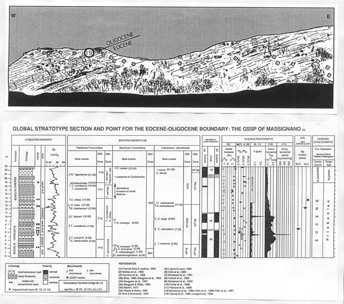
Fig. 5 - Integrated stratigraphy of the GSSP section in the Massignano quarry.
References
Alvarez, L.W., Alvarez, W., Asaro, F., and Michel , H.V., 1980,
Extraterrestrial cause for the Cretaceous-Tertiary extinction: Science v.
208, p. 1095-1108.
Alvarez, W., Asaro, F., Michel, H.V., and Alvarez. L.W., 1982, Geochemical
anomalies near the Eocene-Oligocene and Permian-Triassic boundaries: In:
Silver L.T., Schultz P.H. (eds.) Geological Implications of Impacts of
Large Asteroids and Comets on the Earth: Geol. Soc. Am., Spec. Pap. 190, p.
517-528.
Bice, D. M., and Montanari, A., 1988, Magnetic stratigraphy of the
Massignano section across the Eocene-Oligocene boundary: in Premoli Silva,
I., Coccioni, R., and Montanari, A. (eds.) 1988, The Eocene-Oligocene
Boundary in the Marche-Umbria Basin, 1988, IUGS Spec. Publ., Aniballi
Publisher, Ancona, 111-118.
Brinkhuis, H., and Coccioni, R., 1995, Is there a relation between
dinocysts changes and iridium after all? Preliminary results from the
Massignano section: in Montanari, A., and Coccioni, R., (eds.) Abstracts
and Field Trips, European Science Foundation - The role of Impacts on the
Evolution of Planet Earth, Ancona, 40.
Capo, R.M., and DePaolo, D.J., 1988, Sr isotopic analysis of marine
carbonates from the Massignano section across the Eocene/Oligocene
boundary: in Premoli Silva, I., Coccioni, R., and Montanari, A. (eds.)
1988, The Eocene-Oligocene Boundary in the Marche-Umbria Basin, 1988, IUGS
Spec. Publ., Aniballi Publisher, Ancona, 189-194.
Clymer, A.K., Bice, D.M., and Montanari, A., 1996, Shocked quartz from the
late Eocene: Impact evidence from Massignano, Italy. Geology 24: 483-486.
Coccioni, R., 1988, The genera Hantkeninidae and Cribrohantkeninidae
(Foraminifera) in the Massignano section (Ancona, Italy): in Premoli Silva,
I., Coccioni, R., and Montanari, A. (eds.) 1988, The Eocene-Oligocene
Boundary in the Marche-Umbria Basin, 1988, IUGS Spec. Publ., Aniballi
Publisher, Ancona, 81-96.
Coccioni, R., Monaco, P., Monechi, S., Nocchi., M., and Parisi, G., 1988,
Biostratigraphy of the Eocene/Oligocene boundary at Massignano (Ancona,
Italy): in Premoli Silva, I., Coccioni, R., and Montanari, A. (eds.) 1988,
The Eocene-Oligocene Boundary in the Marche-Umbria Basin, 1988, IUGS Spec.
Publ., Aniballi Publisher, Ancona, 50-80.
Farley, K., Montanari, A., Shoemaker, E., and Shoemaker, C., 1988,
Geochemical evidence for a comet shower in the late Eocene: Science, v.
280, p. 1250-1253.
Glass B.P., 1990, Chronostratigraphy of Upper Eocene microspherules.
Comment and Reply: Palaios v. 5, p. 387-390.
Glass, B.P., and Burns, C.A., 1987, Late Eocene crystal-bearing spherules:
two layers or one? Meteoritics, v. 22, p. 265-279.
Glass B.P., Hall, C.M., and York, D., 1986, 40Ar/39Ar laser-probe dating of
North American tektite fragments from Barbados and the age of the
Eocene-Oligocene boundary: Chemical Geology, v. 59, p. 181-186
Gonzalvo, C., and Molina, E., 1992a, Estudio cuantitativo de los
foraminiferos planctònicos en el estratotipo del lìmite Eoceno/Oligoceno en
Massignano (Apeninos, Italia): Geogaceta, Soc. Geol. España, 12: 64-67.
Gonzalvo, C., and Molina, E., 1992b, Bioestratigrafìa y cronoestratigrafìa
del trànsito Eoceno-Oligoceno en Torre Cardela (España) y Massignano
(Italia). Rev. Esp. Paleont., 7: 109-126
Lowrie, W., and Lanci, L., 1994, magnetostratigraphy of Eocene-Oligocene boundary sections in Italy: No evidence for short subchrons within chrons 12R and 13R: Earth Plan. Sco.Lett., 126: 247-258.
Hazel, J. E., 1989, Chronostratigraphy of upper Eocene microspherules:
Palaios, v. 4, p. 318-329
Huber, H., Koeberl, C., King, D.T., Petruni, L.W., and Montanari, A., 1999,
High-resolution iridium stratigraphy across a distal impactoclastic layer
in the late Eocene type section of Massignano, Italy: Meteoritic and
Planetary Science, v. 34, p.A56.
Keller, G., D'Hondt S.L., Orth, C.J., Gilmore, J.S., Oliver, P.Q.,
Shoemaker, E.M., and Molina, E., 1987, Late Eocene impact microspherules:
stratigraphy, age, and geochemistry: Meteoritics, v. 22, p. 25-60.
Koeberl, C., and Glass, B.P., 1988, Chemical composition of North American
microtektites and tektite fragments from Barbados and DSDP 612 on the
continental slope off New Jersey: Earth. Plan. Sci. Lett. v. 87, p. 286-292.
Lanci, L., Lowrie, W., and Montanari, A., 1996, Magnetostratigraphy of the
Eocene/Oligocene boundary in a short drill-core: Earth and Plan. Sci.
Lett., v: 37-48.
Langenhorst, F., 1996, Characteristics of shocked quartz in late Eocene
impact ejecta from Massignano (Ancona, Italy): clues to shock conditions
and source crater: Geology, 24: 487-490.
Lowrie, W.., Napoleone, G, Perch-Nielsen, K., Premoli Silva, I., and
Toumarkine, M., 1982, Paleogene magnetic stratigraphy in Umbrian pelagic
carbonate rocks: The Contessa sections, Gubbio: Geol. Soc. Amer. Bull. v.
93, p. 414-432.
Lowrie, W., and Lanci, L., 1994, magnetostratigraphy of Eocene-Oligocene
boundary sections in Italy: No evidence for short subchrons within chrons
12R and 13R: Earth Plan. Sco. Lett., 126: 247-258.
Mattias, P., Crocetti, G., Barrese, E., Montanari, A., Coccioni. R.,
Farabollini, P., Parisi, E., 1992, Caratteristiche mineralogiche e
litostratigrafiche della sezione eo-oligocenica di Massignano (Ancona,
Italia) comprendente il limite Scaglia Variegata-Scaglia Cinerea: Studi
Geologici Camerti, 12: 93-103.
Miller, K.G., Berggren, W.A., Zhang, J., and Palmer-Juglson., A.R., 1991,
Biostratigraphy and isotope stratigraphy of Upper Eocene microtektites at
Site 612: How many impacts?: Palaios v. 6, p. 17-38.
Molina, E., Gonzalvo, C., and Keller, G., 1993, The Eocene-Oligocene
planktic foraminiferal transition: Extinctions, impacts and hiatuses: Geol.
Mag. 130: 483-499.
Montanari, A., 1983, K-Ar dating of volcanic biotites in pelagic limestones
bracketing the Eocene-Oligocene boundary in the Gubbio sequence. In: Baldi
T (ed.) Report of the TEE Meeting in Visegrad (Hungary), TEE News, Project
174, Newsletter 6, p. 3.
Montanari, A., 1988, Geochemical characterization of volcanic biotites from
the Upper Eocene-Upper Miocene pelagic sequence of the Northern Apennines:
in Premoli Silva, I., Coccioni, R., and Montanari, A. (eds.) 1998, The
Eocene-Oligocene Boundary in the Marche-Umbria Basin, 1988, IUGS Spec.
Publ., Aniballi Publisher, Ancona, 209-228.
Montanari, A., 1990, Geochronology of the terminal Eocene impacts: an
update. In: Sharpton VL and Ward PD (eds.) Global Catastrophes in Earth
History, Geol. Soc. Am., Spec. Pap., p. 247, p. 607-616.
Montanari, A ., 1991, Authigenesis of impact spheroids in the K/T boundary
clay from Italy: new constraints for high-resolution stratigraphy of
terminal Cretaceous events: Jour. of Sed. Petrology , v. 61, p. 315-339.
Montanari, A., Asaro, F., Kennett, J. P., and Michel, E., 1993, Iridium
anomalies of Late Eocene age at Massignano (Italy), and in ODP Site 689B
(Maud Rise, Antarctica): Palaios, 8: 420-437.
Montanari, A., Deino, A., Drake, R., Turrin, B. D., De Paolo, D. J., Odin,
S. G., Curtis, G. H., Alvarez, W., and Bice, D. M., 1988, Radioisotopic
dating of the Eocene-Oligocene boundary in the pelagic sequence of the
Northern Apennines: in Premoli Silva, I., Coccioni, R., and Montanari, A.
(eds.) 1998, The Eocene-Oligocene Boundary in the Marche-Umbria Basin,
1988, IUGS Spec. Publ., Aniballi Publisher, Ancona, 195-208.
Montanari, A., and Odin, G. S., 1989, Eocene-Oligocene boundary at
Massignano (Ancona, Italy): Potential boundary stratotype: 28th IGC
Congress, Washington D.C., Abstracts, 2: 453.
Montanari, A., Sandroni, P., Clymer, A., Collins, J., Lanci, L., and
Lowrie, W., 1994, Preliminary report on a core drilled across the
Eocene-Oligocene boundary in the type locality of Massignano (Italy): The
Massicore: IUGS-SOG Bull. Liais. Info., Paris, 12: 13-16.
Nocchi, M., Monechi, S., Coccioni, R., Madile, M., Monaco, P., Orlando, M.,
Parisi, G., and Premoli Silva, I., 1988, The extinction of Hantkeninidae as
a marker for recognizing the Eocene/Oligocene boundary: A proposal: in
Premoli Silva, I., Coccioni, R., and Montanari, A. (eds.) 1998, The
Eocene-Oligocene Boundary in the Marche-Umbria Basin, 1988, IUGS Spec.
Publ., Aniballi Publisher, Ancona, 249-252.
Oberli, F., and Meier, M., 1991, Age of Eocene-Oligocene boundary in the
Marche-Umbria basin, Italy, by high resolution U-Th-Pb dating: Terra, 3:
286.
Obradovich, J.D., Snee, L.W., and Izett, G.A., 1989, Is there more than one
glassy impact layer in the Late Eocene?: Geol. Soc. Am. Abstracts with
Program, p. A134.
Odin, G.S., Clauser, S., and Renard, M., 1988a, Sedimentological and
geochemical data on he Eocene/Oligocene boundary at Massignano (Ancona,
Italy): in Premoli Silva, I., Coccioni, R., and Montanari, A. (eds.) 1998,
The Eocene-Oligocene Boundary in the Marche-Umbria Basin, 1988, IUGS Spec.
Publ., Aniballi Publisher, Ancona, 175-186.
Odin, G.S., Guise, P., Rex, D.C., and Hunziger, H., 1988b, K/Ar and
39Ar/40Ar geochronology of Late Eocene biotites from the northeastern
Apennines: in Premoli Silva, I., Coccioni, R., and Montanari, A. (eds.)
1998, The Eocene-Oligocene Boundary in the Marche-Umbria Basin, 1988, IUGS
Spec. Publ., Aniballi Publisher, Ancona, 239-248.
Odin, G.S., and Montanari, A., 1988, The Eocene/Oligocene boundary at
Massignano (Ancona, Italy): A potential Stratotype for the E/O boundary: in
Premoli Silva, I., Coccioni, R., and Montanari, A. (eds.) 1998, The
Eocene-Oligocene Boundary in the Marche-Umbria Basin, 1988, IUGS Spec.
Publ., Aniballi Publisher, Ancona, 253-263.
Odin, G. S., and Montanari, A., 1989, Age radiométrique et stratotype de la
limite Éocène Oligocène: C. R. Acad. Sci. Paris, 309: 1939-1945.
Odin, G. S., Montanari, A., Deino, A., Drake, R., Guise, P., Kreuzer, H.,
and Rex, D.C., 1991, Reliability of volcano-sedimentary biotite ages around
the Eocene/Oligocene boundary: Chem. Geol. (Isot. Geosci.), 86: 203-224.
Parisi, G., and Coccioni, R., 1988, Deep water benthic Foraminifera at the
Eocene/Oligocene boundary in the Massignano section (Ancona, Italy): in
Premoli Silva, I., Coccioni, R., and Montanari, A. (eds.) 1988, The
Eocene-Oligocene Boundary in the Marche-Umbria Basin, 1988, IUGS Spec.
Publ., Aniballi Publisher, Ancona, 97-110.
Pierrard, O., Robin, E., Rocchia, R., & Montanari, A., 1998,
Extraterrestrial Ni-rich spinel in upper Eocene sediments from Massignano,
Italy: Geology, v. 26, p. 307-310.
Pomerol, Ch., and Premoli Silva, I. (eds), 1986, Terminal Eocene Events,
Elsevier Science Publishers B. V., Amsterdam, pp. 153
Premoli Silva, I., Coccioni, R., and Montanari, A. (eds.) 1988, The
Eocene-Oligocene Boundary in the Marche-Umbria Basin, 1988, IUGS Spec.
Publ., Aniballi Publisher, Ancona, 1-268.
Premoli Silva, I., and Montanari, A., 1989, Intercorrelation of Time
Scales: Example of multidisciplinary study from Umbria-Marche pelagic
sequences (Italy) at the Eocene-Oligocene transition: 28th IGC, Washington
D. C., Abstracts, 2: 639.
Premoli Silva, I., and Jenkins, D.J., 1993, Decision on the
Eocene-Oligocene boundary stratotype: Episodes, 16: 379-381.
Raup, D.M., and Sepkoski J.J.Jr., 1982, Mass extinctions in the marine
fossil record: Science, v. 215, p. 1501-1503.
Saunders, J.B., Bernoulli, D., Müller-Merz, E., Oberhänsli, H.,
Perch-Nielsen, K., Riedel ,W.R., Sanfilippo, A., and Torrini, R.Jr., 1984,
Stratigraphy of the late Middle Eocene to Early Oligocene in the Bath Cliff
section, Barbados, West Indies: Micropaleontology, v. 30, p. 390-425.
Vonhof, H.B., Smit, J., Brinkhuis, H., and Montanari, A., 1998, Late Eocene
Impacts accelerated global cooling? in "The strontium Stratigraphic record
of selected geologic events" by H.B. Vonhof (PhD Thesis), Academisch
Proefshrift, University of Utrecht, p.77-90.
__________________________________________________________________________________________
Stratigraphy of the Triassic / Jurassic boundary at Pania di Corfino, and the Romanoro outcrop in the Dolo Stream Valley.
Leaders: Alessandro Colombetti1 and Francesco Nicolodi2
1Prof. Alessandro Colombetti
University of Milano – Bicocca
Department of Geological Sciences and Geotechnologies
Via Mangiagalli, 34 Milano – ITALY
2
Dr. Francesco NicolodiUniversity of Milano
Department of Earth Sciences
Via Mangiagalli, 34 Milano - ITALY
Friday, September 10, 1999
8.00 – Departure: Castelnovo ne’Monti
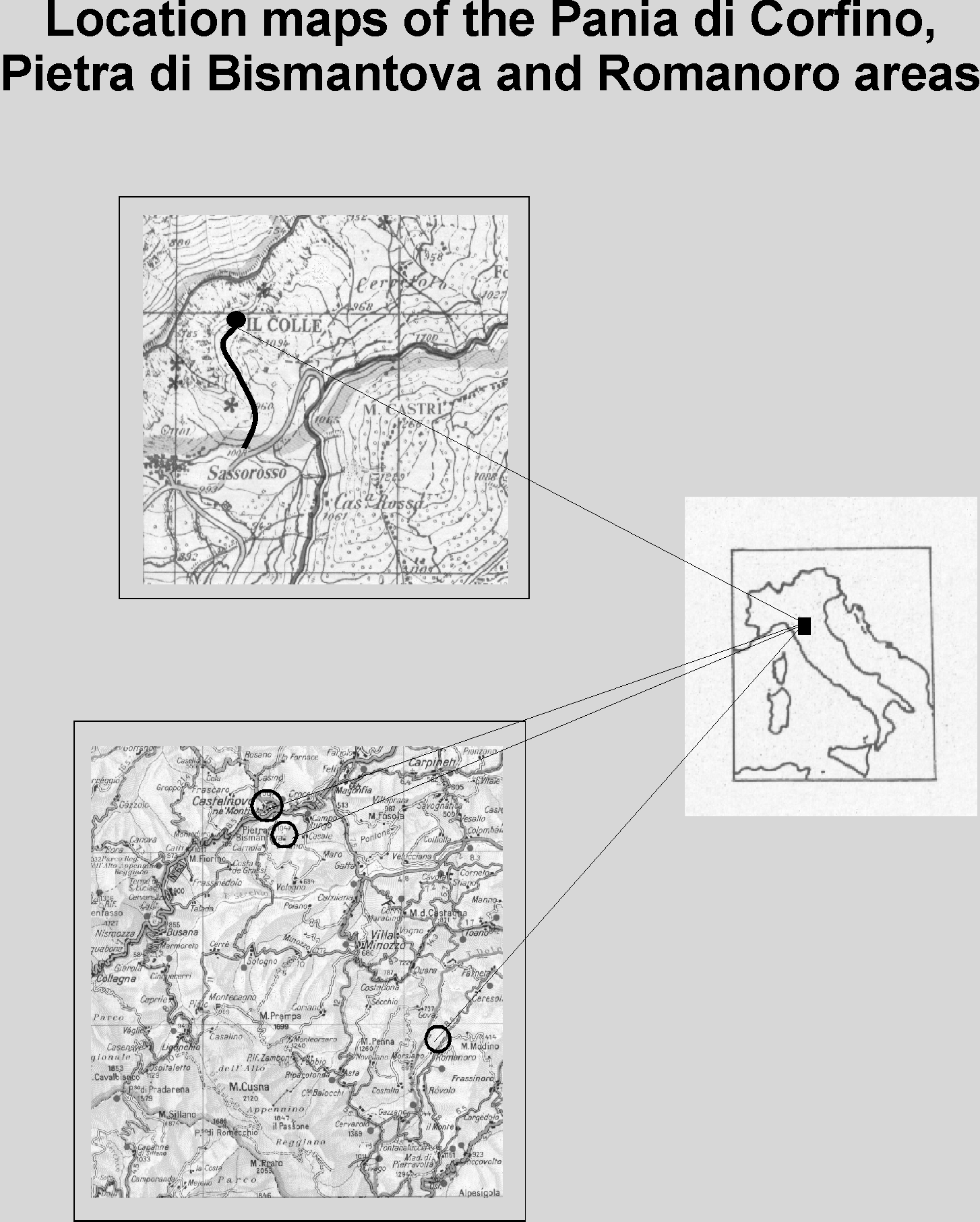
11.00
STOP 1 – Sassorosso Town: Panoramic view of Pania di Corfino and its geological setting.
From this point we can see the complete stratigraphical sequence of Tuscany Basin, from Macigno to Pania di Corfino Formation.
On the right side, at the background, you can see the highest heights (Mt. Cella, 1946 mt; Mt. Vecchio, 1982 mt; Mt. Prado, 2054 mt) of the area, made of the turbiditic sediments of Macigno.
These sediments testify the first arrival of turbidites, due to the apenninic orogenetic belt.
The contact between Scisti Policromi and Macigno occur at Foce di Terrarossa (1141 mt).
Here the outcropping area is not in good exposure, nevertheless the contact is sharp between the two different litotypes, because of the suddenly arrival of the turbidite currents in to the pelagic basin of the Scisti Policromi.
Along the SS. 24 route, near Casina Rossa, you can see the Scisti Policromi Formation, composed by argillitic, massive reddish layers, with greenish interbedded marly layers.
The exterior morphology of such layers is due probably to the deeply reworking operated by dwelling organism in the sediments.
Witnesses of such activity are the ramified structures of centimeters dimentions, which represents the old house tunnels and food traces.
The entire outcrop present a secondary cleavage and deeps towards the east.
On the left side you can see the top of the hill were lies the little town of Sassorosso.
The name of this town derived from the presence of the red rocks of the Rosso Ammonitico Formation (at the top of the hill), while beneath it lies the Calcare Massiccio Formation, dipping towards E – ESE.
A series of antiappenninic faults separes the Rosso Ammonitico Formation to the Calcare Selcifero di Limano one, and this latter from Scisti Policromi.
In front of you, on the other side of the Il Fiume Stream Gorge [Fig. 1], there is a good exposure of Retic – Hettangian sediments (Pania di Corfino Formation), which present a low anticline tectonical structure, with the axial dipping toward the east.
It’s notable the good stratification in thin layers and megabeds of Pania di Corfino Formation, in opposition of the deeply fracturation of the sub-vertical and massive formation of Calcare Massiccio, which has produced a very huge accumulation of detritus slope.
At the top of Pania di Corfino lays a little layer of Rosso Ammonitico Formation.
In the outcrop the Pania di Corfino Formation presents two different litologies, recognised by different morphologies and kind of vegetation.
The lower a middle part of the formation is composed by about 180 meters of dolomitic limestones, till 5 meters thicked. The higher one, sicked about 80 meters, is composed by calcareous layers, thicken no more than one meter, with interbedded marlstones, more frequent toward the top of the formation. The layers are rich enough of Retic fossils.
At the passage of the overlaying Calcare Massiccio, the rise a 1.50 meters thicken marlstones, in which some quartzose granules, of silt dimensions have been found (Bice et al., 1992).
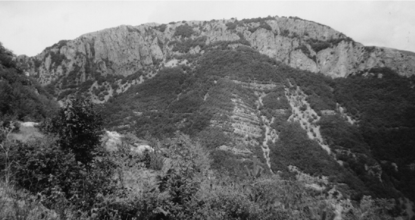
Figure 1 = View of Pania di Corfino from Sassorosso Town. You can see the passage between the Pania di Corfino Formation (stratified, bottom) and the Calcare Massiccio Formation (massive, top). The black line is the Triassic / Jurassic boundary.
They present a crystalline deformed structure, due to the very high pressure. Such deformation are referred to a great meteoric impact at the end of Triassic age, which had produced the so-called "Shocked Quartz", on the quartzose crystals present in the rocks involved in the impact event.
The incredible explosion should have produced also a long serie of meteorological phenomena so strong to modify the original climatic condition, and bring out the extinction of some groups of animals, that really happened at the Triassic / Jurassic boundary.
11.50
STOP 2: Triassic / Jurassic boundary near Il Colle.
The Triassic / Jurassic (T/J) boundary represents one of the five most severe marine extintions in Phanerozoic history and is a time of important terrestrial extintions.
The most important T/J sections in the world are the Kendelbach (Austria), New York Canyon (Nevada, United States) and the Pania di Corfino (Italy).
Recent developments supporting one or more asteroid or comet impacts as the primary cause of the K/T mass extintions, Permo/Trias and T/J.
Traces of ejecta were found by Bice et al. (1992) in the Il Fiume Stream Gorge, near the town of Corfino (Tuscany, Italy).
Another good exposure of the T/J boundary is in the outcrop of Il Colle, near the town of Sassorosso [Fig. 2].
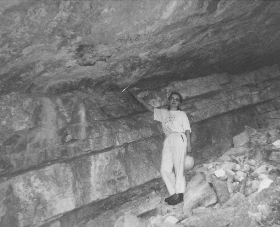
Figure 2 = The Triassic / Jurassic boundary at Il Colle. The hammer shows the boundary.
At the top there is the Calcare Massiccio and at the bottom the last stratum of the Pania di Corfino Formation.
In the Il Colle outcrop we can see the last 2 meters of the Pania di Corfino formation.
This formation consist in limestones, with two principal facies: about 80% of skeletal packstone and wackestone; the remaining 20% is biomicrite and sparsed biomicrite.
Calcareous shale is interbedded with the limestone.The first facies contains bivalves, benthic foraminifera, echinoderms, gasteropods and rare serpulids. Bice et al. (1992) interprets this facies as rapresenting a fully marine, shallow subtidal habitat.
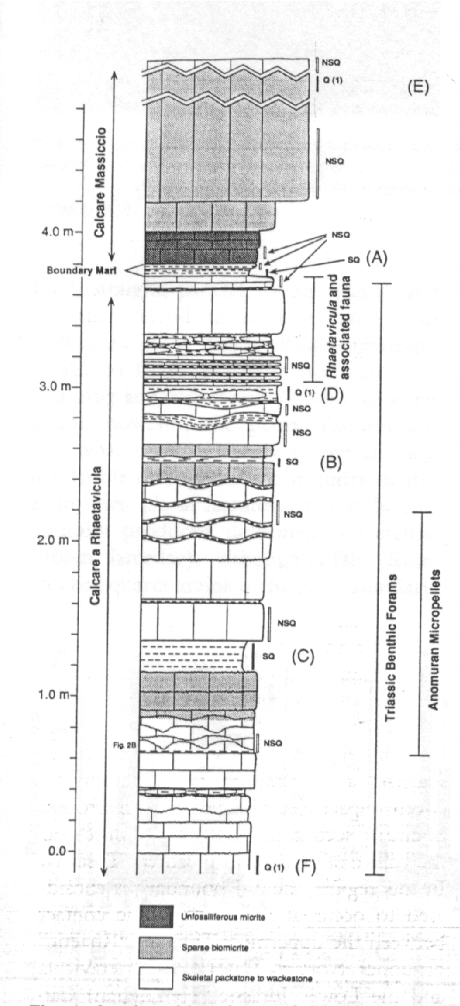
The second facies contains rare uniserial foraminifera and anomuran micropellets. The boundary shale is an unfossiliferous micritic shale.
Immediately above the boundary shale, the first 26 cm of the Calcare Massiccio is unfossiliferous, laminated micrite.
If we see the Il Fiume section [fig. 3], the shocked quartz occur in 3 differents layers: the lower half of the boundary shale (A), and in two shale beds located at 1.2 (B) and 2.4 m (C) below the boundary. The same there is at Il Colle outcrop.
The shocked quartz grains are the 20% of the total amount of detrital minerals found in the shales. These grains are very thin (1 to 2 microns), with closely spaced planar zones that are optically discontinuous with the rest of the grains. In some grains the lamellae are decorated by small inclusions of bubbles. This type of quartz is very similar to the K/T boundary one.
Other levels with a minor concentration of quartz grains with single set of lamellae was found in a shale layer 0.7 m (D) below the boundary, 3.7 m (F) below and 2.6 m (E) above the boundary.
The resulting average rate of accumulation suggests that the beds A to C may span about 150,000 years (Bice et al., 1992), well within the expected time of a comet shower, like proposed by Hut et al. (1987).
14.00 – Lunch
17.30
STOP 3: The Romanoro outcrop.
In order to understand the problem of dating the Romanoro event, it’s important to know the geological and structural setting of this area of the Apenninic chain.
The Romanoro Flysch is a tectonic scale, part of the Sestola Vidiciatico Tectonic Unit.
This unit is a tectonic belt interbedded between the Ligurain Unit, at the top, and the Tuscany one, at the bottom. Shales with scales of calcareous formations and ophiolites mainly compose the Sestola Vidiciatico. The oversthrusting of the Ligurian nappes and the underthrusting of the Tuscany ones had erased the original relationships between the rocks now enclosed in the intermediate tectonic unit.
Moreover the folding of the Tuscany units in two large anticlines, as we can see in the tectonic windows of Gazzano and Gova, have complicated the geological situation [fig. 4].
Starting from the top to the bottom of Monte Modino Mt. (1410 meters) we can see:
- The Ligurian Units, with the Venano Stratigraphic Sequence: the Poggio Castellina Sandstones and the Poggio Mezzature Shales. This sequence is the upside down part of a regional scale anticline. A regional thrust line divides this unit to the one below.
- The Sestola Vidiciatico unit, with its scales. In the Romanoro area we can see: the Calcareous Shale Complex, that envelope tectonically the Castellaccio "Black" Shales and the Romanoro Flysch.
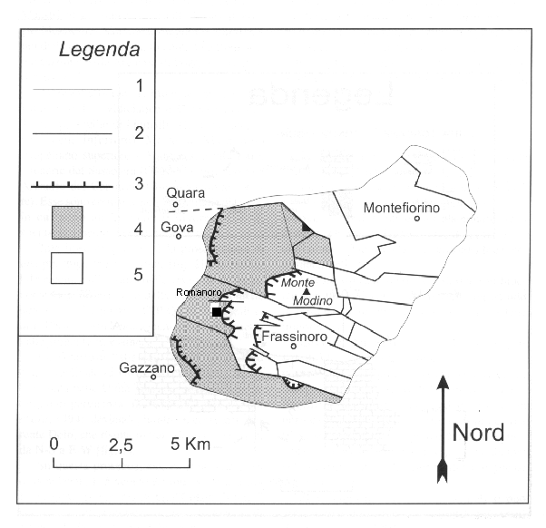
Figure 4 = Structural Sketch Map of Montefiorino Area. 1) Perimeter of the investigated area; 2) Faults; 3) Thrusts; 4) Sestola-Vidiciatico and Tuscany Units; 5) Ligurian Units. From Colombetti e Nicolodi, 1998 – Modified.
- The Tuscany Units, not outcropping in this place, but that are visible in the nearest window of Gazzano. In this area there is the Cervarola Stratigraphic Sequence: the Poggi di Fontanaluccia Siltstones, the Civago Marlstones and the Cervarola Sandstones.
Calcareous siltstones, marlstones and shales of turbiditic origin mainly form the Romanoro Flysch.
The stratigraphic sequence near the route outcrop is normal. The analysis of the sedimentologic structures show a little part of the Bouma Sequence with only the Td and Te intervals, and this demostrate a sedimetation under a diluite turbidite currents, with low energy deposition. The strata are horizontal or have a little (10°) dip towards south – southeast [fig. 5].
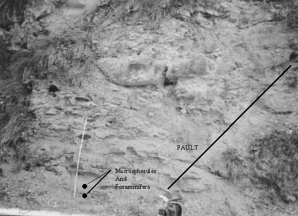
Figure 5 = The Romanoro "route" outcrop. On the bottom of the outcrop were sampled the microspherules an the foraminifera.
In the ancient quarry on the left side, ten - twenty meters up from the route outcrop, the sequence is upside down, with the presence of megabeds. This tectonic passage is covered, but we can suppose the presence of an isoclinal fold-fault structure, due to the rapid changing of the deposition polarity.
On the bottom of the calcareous siltsones it’s easy to find traces of paleocurrents and/or dwelling organisms.
At the top of the Romanoro Flysch, the transition to the uppermost Castellaccio Shales is marked by a thin thrusting surface, covered by a calcite vein; however we formulate the hypotesis that originally these two formations was in stratigraphic contact.
All the formation is deeply affected by faults, joints and a secondary cleavage due to the formation of Gazzano and Gova anticlines.
In the "route" outcrop we can see a sequence of little faults, with calcite veins, and a large boudinage of the calcareous siltstone beds.
The metallic microspherules were found in the levels FR 1 and 2. The SEM, mineralogical and metallographical analyses have confirmed the iron meteorite origin.
During new sampling, were found glassy microspherules, now under analyses; the presence of impact materials will be sure if it was confirmed their origin.
The datation of the sediments and of the meteoritic event is an open question.
New data (see in this volume) have partially clarified the original age of the Romanoro Flysch.
In consequence of the large abundance of Tertiary foraminifera (mainly we can observe an Eocene – Oligocene fauna), the age of the sediments is younger than the K/T event.
This hypotesis has been confirmed by the presence of Miocenic planctonic foraminifera, in bad conservation, and the results of the 86Sr/87Sr datation.
The ageis: Lower Miocene.
The analyses of calcareous nannoplancton show a unique Cretaceous age.
Due to the tectonic situation it’s very hard to collocate this formation into a sure sedimentary basin; probably the original basin was the Epiligurian one. This type of basin was joined to the thrusting of Ligurian units, that during their movement created this ensialic basin in a close little ocean.
References
AA. VV., 1992, L’Appennino Tosco – Emiliano, in Guide Geologiche Regionali. Ed. BE-MA, 329 p.
AA. VV., (in press), Emilia Romagna Regional Index of Interesting Geological Places (Geotopi) – The Romanoro Place. Ed. Reg. Emilia Romagna.
Bertolli A. and Nardi R., 1966, La geologia delle valli del Dolo e del Dragone (Appennino tosco-emiliano). Mem. Soc. Geol. It., 5, 139 – 164.
Bice D.M., Newton C.R., McCauley S., Reiners P.W. and McRoberts C.A., 1992, Shocked quartz at the Triassic – Jurassic Boundary in Italy. Science, 255, 443 – 446.
Colombetti A., Ferrari G. e Nicolodi F., 1997, Su alcune microsferule metalliche ritrovate all’interno di uno strato calcareo marnoso, appartenente al Flysch di Romanoro (Unità Sestola - Vidiciatico), nell’Alto Appennino modenese. Ateneo Parmense Acta Naturalia, 33.
Colombetti A., Ferrari G., Nicolodi F. and Panini F., 1998, Some metallic spherules in calcareous marly sediments of the Romanoro Flysch, Sestola - Vidiciatico tectonic unit (Modena district, Northern Apenines, Italy). Planetary and Space Sciences, 46, Special Paper, Parigi.
Colombetti A. and Nicolodi F., 1998, La Sorgente Sulfurea di Farneta nella valle del T. Dolo (Prov. Di Modena). Ateneo Parmense Acta Naturalia, 34.
Colombetti A. and Nicolodi F., (in press), Evidences of meteorite impact in a turbidite sequence of northern Apennines (Modena district - Italy). IGCP384 Annual Meeting, Budapest, Hungary, 26 Sept. - 3 Oct. 1998.
Daniele G., Mochi E. and Plesi G., 1996, L’insieme ligure – emiliano dell’Appennino modenese: unità tettoniche e successioni stratigrafiche nella zona di Frassinoro. Atti Soc. Tosc. Sci. Nat. Mem., serie A, 102, 147 – 158.
Rentz K., 1971, Zur Geologie der Zone zwischen der Secchia und dem Apennin Hauptkamm. Diss. Freie Univ., Berlin.
Reutter K.J., 1969, La Geologia dell’alto Appennino Modenese tra Civago e Fanano, e considerazioni geotettoniche sull’unità M. Modino – M. Cervarola. Ateneo Parmense Acta Naturalia, 5 , 1 – 88.
Workshop Programme
September, 7
9.00 Opening
- Introduction, by Prof. Alessandro Colombetti
9.30 Spherule occurrence and stratigraphical boundaries
Chair of the session: Prof. Francois Marini
- The K/T Boundary in Brazilian Marginal Sedimentary Basins and Related Spherules
G. A. ALBERTÃO and A. A. GRASSI
- The Permian -Triassic supernova impact
Cs. H. Detre, I. Tóth, Gy. Don, A.Z. Kiss, I. Uzonyi, P. Bodó, Zs. Schléder
Coffee Break
- Black, magnetic spherules from the Devonian-carboniferous boundary (Montagne Noire, France) –– A preliminary report
Gy. Don , Cs. H. Detre , P. Solt
- On the Cenomanian - Turonian boundary in Albania and the possibility for the spherule research.
J. Hoxha
Lunch
14. 30 Cosmic Events, Impacts and Geology
Chair of the session : Prof. Gilberto Albertao
- Olivine spherules and droplets from the pannonian basalt of Szentbékkálla
Sz. Bérczi, Cs. H. Detre, Gy. Don, P. Solt, I. Uzonyi
J.M. Thery, P. Solt, P. Crosta
Coffee Break
- Spherules and Senonian formations in Hungary
A. SIEGL-FARKAS
- Panther Mountain Buried Impact Crater Is Confirmed
Y.W Isachsen
- Magnetic fines from the Kaali impact-site (Holocene, Estonia) : preliminary SEM investigation
F. MARINI 1 , A. RAUKAS 2 and R. TIIRMAA
Welcome Party
September, 8
9.30 Spherule occurrence and geology
Chair of the session: Prof. Csaba Detre
- Age determination of Romanoro Flysch
A. Colombetti, G. Ferrari and F. Nicolodi
- Investigation of Impact and Extraterrestrial Spherules in the Kaali Area (Island of Saaremaa, Estonia) for the purposes of Regional Stratigraphy.
Raukas, A.
Coffe break
- Finland and Estonia Impact Craters - Excellent Spots for a Field Trip
I. Vetvicka
- Terrestrial spheres in northern Apennines sediments
A. Colombetti and F. Nicolodi
Closing of the works and general discussion
LIST OF PARTECIPANTS
Albertao G.A. – Petrobras/EPBC/GERET/GEREV –C – Av. E. Agostinho 665, 27913, Macaé, RJ, Brazil
Biggioggero B. - University of Milano, Mineralogy and Petrology Section , via Botticelli 23, 20133 Milano, Italy
Cara F. - Albanian Geological Survey, Institute of Geological Research. Blloku "Vasil Shanto" Tirane, Albania
Colombetti A. - University of Milano-Bicocca, Dept. Of Geological Sciences and Geotechnologies, via Mangiagalli 34, 20133 Milano, Italy
Detre Cs. - Geological Institute of Hungary, H-1143 Budapest, Stefánia út 14, Hungary
Don Gy. - Geological Institute of Hungary, H-1143 Budapest, Stefánia út 14, Hungary
Ferrari G. - University of Milano, Dept. Of Earth Sciences, via Mangiagalli 34, 20133 Milano, Italy
Fioretti A. - CNR, Centro Studi Geodinamica Alpina, C.so Garibaldi, 37 - 35137 Padova Italy
Gardi A. - University of Milano, Dept. Of Geophysics, via Cicognara 7 , 20100 Milano, Italy
Glikson A. - Research School of Earth Science Australian National University, Canberra, ACT 0200, Australia
Hoxha J. - Albanian Geological Survey, Institute of Geological Research. Blloku "Vasil Shanto" Tirane, Albania
Iaccarino S. – University of Parma, Parco Area delle Scienze 157a – 43100 Parma, Italy
Isachsen Y.W. - New York State Geological Survey/State Museum, Albany, NY 12230 (USA); or HANLEY, Kristy, Dept. of Earth and Atmospheric Sciences, University at Albany, Albany, NY 12222 (USA)
Jobstraibizer P. - Dip.to di Mineralogia e Petrologia dell’Università, C.so Garibaldi, 37 – 35137 Padova - Italy
Marini F. – E.N.S.G., Rue du Doyen Roubault, EP40, 54501 Vandoeuvre les Nancy Cedex, France
Montanari A. - Osservatorio Geologico di Coldigioco 62020 Frontale di Apiro - Italy
Nicolodi F. – University of Milano, Dept. Of Earth Sciences, via Mangiagalli 34, 20133 Milano, Italy
Panini F. – University of Modena, Dept. of Earth Sciences, P.le S. Eufemia 19, 41100 Modena, Italy
Pohl H. - Institute of Geology at Tallinn Technical University, 7 Estonia Avenue, Tallinn 10143, Estonia
Solt P. - Geological Institute of Hungary, H-1143 Budapest, Stefánia út 14, Hungary
Siegl - Farkas A. - Geological Institute of Hungary, H-1143 Budapest, Stefánia út 14, Hungary
Thery J.M. - 9 Jardin Gabrieli, Tours, France
Vetvicka I. - Charles University, Department of Geology, Pøevoznická 14 , 143 00 Prague 4 Czech Republic